
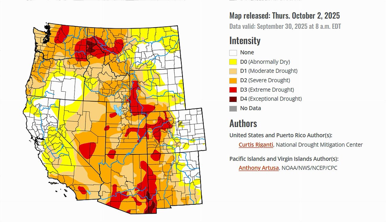
- Heavy rains improved parts of Arizona, New Mexico, Nevada, and Wyoming.
- Severe drought expanded in south-central Utah.
- Colorado’s Front Range and southeast Wyoming saw significant recovery.
- Despite the shutdown, the U.S. Drought Monitor remains on schedule.
Saturday, October 4, 2025 — The latest U.S. Drought Monitor , released on October 2, 2025, shows a complex picture across the country. Widespread rains stretched from southern Missouri and Arkansas into the Northeast, providing some relief in areas facing dryness. However, persistent heat and dry weather worsened conditions in the northern Great Plains, Upper Midwest, and parts of New England.
Flash droughts also emerged in the Southeast, where rapid drying hit crops in southern Georgia. Above-normal temperatures dominated nearly everywhere, with many regions experiencing September heat between 6 and 10 degrees above average.
Importantly, the Drought Monitor reminded the public: “Despite the federal government shutdown, the U.S. Drought Monitor map and its associated products remain unaffected and will continue to be released on schedule.”
Colorado River Basin Focus.
The seven states in the Colorado River Basin — Arizona, California, Colorado, Nevada, New Mexico, Utah, and Wyoming — experienced both improvements and setbacks this week.
Arizona and New Mexico.
Heavy rains brought more than 2 inches to central Arizona, triggering deadly flooding in some locations but also improving drought conditions. Central and southern Arizona received sufficient moisture to warrant one-category improvements on the drought map. In west-central New Mexico, similar rainfall totals led to localized gains.
Nevada.
Central and northeast Nevada, particularly along the Utah border, also benefited from isolated heavy rain. This moisture was sufficient to trim back drought categories in some pockets.
Utah.
Utah saw mixed results. While border areas near Nevada improved, severe drought expanded in south-central Utah. Long-term precipitation deficits, combined with low soil moisture and declining streamflow, further exacerbated conditions, pushing them into a severe status.
Colorado and Wyoming.
Northern Colorado and southeast Wyoming enjoyed significant improvement. Rainfall over the Front Range and into Wyoming replenished soil moisture and increased streamflows, resulting in widespread one-category upgrades. In contrast, the San Luis Valley of south-central Colorado experienced worsening conditions, with moderate drought expanding after a dry spell, reducing vegetation health.
California.
California remained drier overall. Most of the state did not receive the kind of widespread precipitation seen in neighboring states. While storms were scattered, they did little to offset long-term water stress.
Looking Ahead.
Between October 1 and October 6, forecasters expect mostly dry weather across much of the country, including southern California and parts of the interior West. However, some areas of northern Nevada, northern Utah, Idaho, northern Wyoming, and southern Montana may see rainfall exceeding three-quarters of an inch.
The outlook for October 7–11 is more promising for the Southwest. The Climate Prediction Center projects strong odds of above-normal precipitation in Arizona and New Mexico. Warmer-than-average conditions are expected across most of the Basin, while temperatures in parts of California, Montana, and neighboring areas may stay closer to normal.