
- Pacific Northwest drenched by heavy rains, but the Southwest stays dry.
- Arizona, New Mexico, and Utah show slight worsening of drought conditions.
- California’s northern coast sees improvement; southern areas remain stable.
- Despite the federal shutdown, the Drought Monitor continues regular updates.
Saturday, November 8, 2025 — As of November 6, 2025, the U.S. Drought Monitor shows a nation split between extremes. While the Pacific Northwest was soaked by repeated storm systems bringing six to ten inches of rain, much of the western and southern United States remained dry. Across the Northeast and Mid-Atlantic, moderate to heavy rain improved conditions that had been unusually dry for several months.
“Despite the federal government shutdown, the U.S. Drought Monitor map and its associated products remain unaffected and will continue to be released on schedule,” the report emphasized, ensuring continuity of data that underpins agricultural and water management planning across the country.
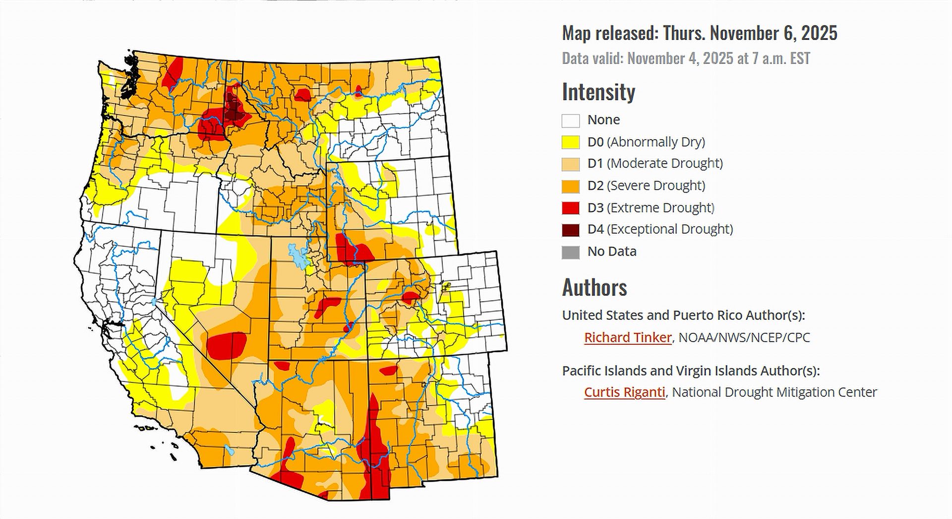
Conditions in the Colorado River Basin.
The seven Colorado River Basin states — Arizona, California, Colorado, Nevada, New Mexico, Utah, and Wyoming — experienced mostly dry conditions during the first week of November, with limited moisture reaching the interior Southwest. Only isolated improvements were reported in parts of southern California and western Colorado, while New Mexico and Arizona continued to struggle with worsening dryness.
Arizona and New Mexico: Persistent Dryness and Local Worsening.
Most of Arizona and New Mexico received little or no rainfall, allowing existing drought patterns to persist. Southeastern New Mexico saw intensification of drought, particularly in areas already dealing with water stress from summer heat. Conditions in southern Arizona remain generally dry, reflecting a slow start to the cool-season moisture period. The report noted that parts of the Southwest “saw areas of intensification in north-central Montana and southeastern New Mexico,” underscoring how dryness reasserted itself after temporary improvement earlier in the fall.
Utah and Colorado: Early Season Watchfulness.
In Utah, the transition into the wet season has been slow. Precipitation totals across most basins remain below normal for this time of year, with only light mountain snowfall reported. Colorado’s western slopes have fared slightly better, though most of the state recorded a dry week. The Climate Prediction Center’s outlook favors warmer and drier conditions through mid-November, suggesting that drought recovery in the region could be delayed until winter storms become more regular.
California and Nevada: North-South Contrast.
The pattern in California remained sharply divided. The northern coast and Cascades region received several inches of rainfall, easing surface dryness, while the interior valleys and southern California saw little measurable rainfall. The Drought Monitor noted that, “given how early it is in the wet season and that normals are ramping upward fairly quickly, improvement in dryness and drought was not as widespread as one might assume.”
In Nevada, conditions remained mostly unchanged, with dry air and limited snowfall at higher elevations. Despite that, water storage levels across much of the state have remained stable following last winter’s strong snowpack.
Wyoming: Minimal Impact from Light Showers.
Only light precipitation reached Wyoming’s western mountains, while the rest of the state remained mostly dry. The Drought Monitor described the High Plains Region as “currently the region least affected by dryness and drought,” noting that less than 40 percent of the area is showing any dryness, and under 18 percent is classified in drought. This indicates relative stability compared to southern basin states.
The Forecast.
Through November 10, the forecast calls for continued rain in the Pacific Northwest, with up to six inches expected in parts of Washington and Oregon. Most of the interior West, including the Colorado River Basin, will likely remain dry with above-normal temperatures. Longer-range projections from November 11–15 favor a return to abnormally wet weather across the High Plains to the Pacific Coast, with the highest odds of heavy precipitation centered on central and southwestern California.
If those storms materialize, they could mark the start of much-needed recharge for Western reservoirs — but for now, the early November snapshot shows a region still teetering between drought persistence and recovery.

True.