- Dry weather persisted across much of the United States.
- Northern California and the Pacific Northwest saw heavy rain.
- Colorado River Basin states remained mostly warm and dry.
- Some improvement occurred in Idaho and western Montana.
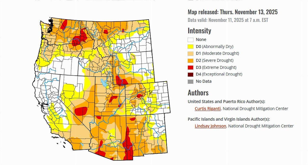
Saturday, November 15, 2025 — The U.S. Drought Monitor released on November 13, 2025 showed another week of contrasting conditions across the country. Large portions of the Great Plains, the south-central United States, the Midwest, the Southeast, and the Southwest saw limited moisture, allowing dryness to expand in several states. According to the report, “Mostly dry weather occurred this week across the Great Plains, Minnesota and Wisconsin, the south-central U.S. and the Southwest.”
In sharp contrast, the northern half of California and the Pacific Northwest were hit with significant precipitation. The Monitor noted that from northern California into the Pacific Northwest, “amounts this week were locally over 3 inches.” Oregon, Washington, northern Idaho, and northwest Montana all received moderate to heavy rainfall or mountain snowfall.
The rest of the country saw a patchwork of improvement and deterioration. In parts of New England, north-central Ohio, and northwest Indiana, recent storms eased short-term deficits. Meanwhile, worsening dryness spread across Texas, Oklahoma, Louisiana, southern Georgia, and Florida. The West also saw a mix of progress and setbacks: Idaho, western Montana, and northwest Oregon improved following strong storms, while north-central Montana continued to dry.
With most of the United States entering mid-November under above-normal temperatures—especially in the Southwest and southern Plains—evaporative demand remained high in many areas, intensifying short-term drought impacts.
Colorado River Basin Conditions.
Arizona.
Arizona remained mostly warm and dry during the week. The Drought Monitor reported that the Southwest experienced temperatures “6-10 degrees above normal” in many locations. Limited precipitation and elevated evaporative demand caused soil moisture to drop further in parts of the state. Portions of western and central Arizona are expected to remain vulnerable heading into late November, with the report highlighting that most areas “from central California southward and eastward were dry.”
California.
California’s conditions diverged sharply between north and south. Northern counties benefited from multiple storm systems, where “northern California received heavier amounts ranging from 2 to locally over 5 inches of precipitation.” These storms helped stabilize short-term water conditions in the Sacramento and Klamath regions. By contrast, central and southern California remained dry through the period, maintaining existing precipitation deficits and keeping soils seasonally stressed.
Colorado.
Colorado saw warmer-than-normal temperatures, especially west of the Continental Divide. The report noted that central and western Colorado were among the areas where temperatures were “4-8 degrees above normal.” While some precipitation reached parts of the central mountains and eastern plains, much of the state experienced continued drying. In south-central Colorado, the Monitor cited “localized degradations… due in part to effects from longer-term precipitation deficits,” suggesting that deep-rooted moisture shortages persisted.
Nevada.
Nevada experienced some of the warmest departures from normal across the West. As part of a region that was “generally the warmest compared to normal,” the state saw temperatures 6–10 degrees above seasonal averages. Precipitation was largely absent outside of far northern Nevada. Continued warmth and limited moisture supported ongoing dryness, particularly in southern and central counties.
New Mexico.
New Mexico remained warm and mostly dry during the period. The Drought Monitor placed southern New Mexico within the subset of states that were significantly warmer than normal. Although the High Plains region to the north received minor precipitation, most of New Mexico experienced another dry week, leaving existing short-term deficits intact.
Utah.
Utah also fell within the broad area of above-normal temperatures stretching across the Southwest. The report highlighted Utah as part of a region where temperatures were “6-10 degrees above normal.” Limited precipitation contributed to the state’s continued dryness, with southern and central Utah remaining especially vulnerable to evaporative losses. No large-scale improvements or widespread degradations were reported, but moisture deficits persisted.
Wyoming.
Wyoming saw mixed conditions. Northwest Wyoming near Yellowstone received over a half inch of precipitation, but the rest of the state remained dry. Much of central and southern Wyoming recorded above-normal temperatures, joining Colorado and Nebraska as part of a warm corridor across the central Rockies. The Monitor reported that portions of western Nebraska, southeast Wyoming, and adjacent areas “continued to dry… and abnormal dryness and some moderate drought grew.” These expanding dry pockets reflect the lingering effects of limited storm activity east of the Continental Divide.
Looking Ahead.
The National Weather Service forecast, issued for November 12–17, called for a shift toward wetter conditions across the West. The Drought Monitor stated that “precipitation amounts from 3-5 inches (locally higher) may fall across large portions of California,” including the Sierra Nevada and southwest coastal regions. Moisture was also expected to reach southeast California, southern Nevada, western and central Arizona, and southwest Utah. Portions of the San Juan Mountains in southwest Colorado may also see an inch or more of precipitation.
For November 18–22, the Climate Prediction Center favored “above-normal precipitation across much of the Contiguous U.S., especially from the Southwest northeastward to the Lower Ohio River Valley.” This pattern may bring the first widespread storm opportunities of the season to parts of the Colorado River Basin, although confidence varies by region.