- Heavy rain and snow improved drought conditions across California, Nevada and parts of the Pacific Northwest.
- Warmer-than-normal temperatures intensified short-term dryness in Wyoming, Montana and Nebraska.
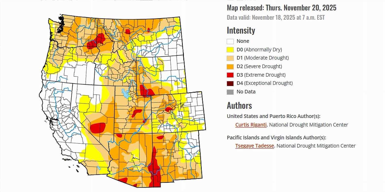
- Portions of Arizona, Utah and New Mexico saw modest improvement after recent precipitation.
- Dry weather continues to pressure large sections of the southern and eastern United States.
Saturday, November 22, 2025 — Across the country, the latest U.S. Drought Monitor paints a divided landscape. Much of the central and eastern United States remained dry during the past week, with only isolated pockets of meaningful rainfall. Colder-than-normal temperatures settled over parts of the Southeast, including southern Georgia and Florida, while warmer-than-normal conditions dominated many states west of the Mississippi River.
In contrast, the West saw widespread rain and snow. Storm systems swept across California, southern Nevada, the Sierra Nevada, the Pacific Northwest and parts of Montana and Idaho. These storms delivered several inches of moisture to some locations, reversing earlier deficits and lifting soil moisture levels in key areas.
Yet even with this active pattern, not every state benefited. Large parts of the southern Plains, central Montana, the western Great Lakes and the Southeast continued to dry out. Streamflows, soil moisture and short-term precipitation deficits worsened in places such as Oklahoma, Texas, southern Georgia and Florida.
With the national backdrop in place, the focus turns to the seven Colorado River Basin states—Arizona, California, Colorado, Nevada, New Mexico, Utah and Wyoming—where storms brought relief to some areas and mixed conditions to others.
California: Widespread Improvement After Heavy Precipitation.
California was one of the biggest beneficiaries of this week’s storm activity. Multiple systems dropped several inches of rain and snow across coastal regions, the Sierra Nevada and parts of southern California. Soil moisture rose sharply, and earlier precipitation deficits diminished or were erased.
These conditions resulted in broad one-category improvements across the state, with some localized two-category improvements near Los Angeles. As water managers evaluate the full effect of this precipitation on groundwater, streamflow and seasonal deficits, additional improvements may be possible.
Temperatures remained warmer than normal statewide, though the warmth did not offset the benefit of the substantial moisture.
Nevada: Gains Focused in the South and Along the Border.
Southern Nevada also received meaningful precipitation, part of the same pattern that soaked California. The storm activity helped ease precipitation deficits and raise soil moisture levels along sections of the Nevada-Utah border.
These gains were not uniform. Northern and central Nevada saw less change, though the statewide picture is more encouraging than in recent months.
Arizona: Localized Improvements in the Southwest.
Parts of southwest Arizona experienced improvements linked to recent storms that moved across California and southern Nevada. Soil moisture, groundwater and streamflow levels responded positively in some locations.
Elsewhere in the state, conditions varied. Short-term precipitation deficits persist in some regions, especially where storm tracks were lighter. Still, the desert Southwest benefitted from the week’s wetter weather.
Utah: Strengthening Conditions Along the Nevada Border.
Precipitation across southwest Utah and areas near the Utah-Nevada border brought welcome improvement. Soil moisture increased, and earlier deficits were curtailed in those regions.
However, the state’s eastern and northern areas experienced a very different week. Warmer-than-normal temperatures and dry conditions held firm, leaving some pockets of moderate and severe drought intact.
Colorado: Mixed Signals Across the State.
Colorado’s moisture picture was split. High-elevation regions received snow, while eastern portions of the state saw little relief and continued warmth. Temperatures in parts of eastern Colorado were as much as twelve degrees above normal.
The southeast plains experienced an expansion of abnormal dryness as short-term precipitation deficits grew. In northwest Colorado, moderate drought filled in where short-term dryness aligned with earlier long-term deficits.
Mountain precipitation helped stabilize conditions in the high country, but lower-elevation areas showed growing signs of stress.
New Mexico: Limited but Notable Moisture.
Forecasted precipitation for southern and eastern New Mexico has been slow to arrive, but portions of the state already show improvement from recent rainfall. The southwest region, in particular, saw some recovery in soil moisture and streamflow.
Still, short-term dryness lingers in other areas, and widespread improvements have not yet taken hold. Conditions remain a patchwork shaped by local storm tracks.
Wyoming: Warmth and Dryness Continue to Pressure Conditions.
Wyoming was one of the warmest states in the West this week, with temperatures twelve degrees or more above normal in some areas. Only select high-elevation locations received notable moisture.
Elsewhere, the combination of warmth and dryness increased soil moisture deficits. Eastern sections of the state experienced short-term precipitation shortfalls similar to those in adjacent Montana. Although widespread drought expansion did not occur in Wyoming, the state’s overall pattern leaned warm and dry.
Looking Ahead for the Colorado River Basin.
Forecasts from the National Weather Service indicate that parts of southern California, southern Arizona and southeastern New Mexico are likely to receive around three-quarters of an inch of precipitation in the coming days. Meanwhile, colder-than-normal temperatures are favored in the northern and central United States, while warmer-than-normal conditions are favored across much of the West from Oregon to the Continental Divide.
Drier-than-normal conditions are likely to redevelop in parts of the Southwest, including coastal California, southeast Arizona, southern New Mexico and southwest Texas, between November 25 and November 29.