- Drought conditions improved in parts of the Pacific Northwest and northern Rockies.
- Snowpack across much of the West remains below normal for mid-December.
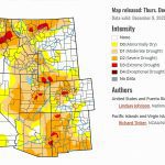
- The Colorado River Basin continues to face mixed conditions shaped by uneven snowfall.
- Several Basin headwater areas remain vulnerable despite recent storms.
Saturday, December 20, 2025 — As of the December 18, 2025, Drought Monitor report , drought conditions across the United States remained highly uneven, reflecting sharp contrasts in temperature and precipitation patterns. Storm systems delivered meaningful moisture to parts of the Pacific Northwest and northern Rocky Mountains, leading to localized drought improvements. In contrast, large portions of the central, southern, and eastern United States experienced limited or uneven precipitation, allowing dryness to persist or intensify in many areas.
Across much of the West, temperatures ran warmer than normal, while colder-than-normal conditions dominated parts of the Midwest and Northeast. Although snow fell in mountain regions, early-season snowpack across much of the country remains below what is typically expected for mid-December. In areas where precipitation fell mainly as snow, colder temperatures slowed improvements in soil moisture and streamflow.
Against this national backdrop, conditions within the Colorado River Basin continue to reflect a complex mix of modest improvements and ongoing challenges.
The Colorado River Basin: A Mixed Early-Winter Picture.
The seven states that rely on the Colorado River—Arizona, California, Colorado, Nevada, New Mexico, Utah, and Wyoming—saw varied drought conditions during the past week, largely driven by the timing, type, and amount of precipitation.
In the northern portions of the Basin, including parts of Wyoming and Colorado, some mountain areas received enough snowfall to support localized improvements. In a few headwater regions, snow water equivalent approached near-normal early-season levels. However, these gains were uneven, and many areas saw limited snowfall combined with above-normal temperatures, which restricted snowpack development.
Utah continues to face notable challenges. Across much of western and central Utah, snow water equivalent remains below 50 percent of normal for this time of year. These deficits supported further drought degradation in north-central and central parts of the state, where warm conditions and limited snowfall persisted.
California and the Upper Basin Headwaters.
In northern California and areas near the Oregon border, recent Pacific storm systems brought beneficial rainfall and mountain snow, leading to short-term improvements where precipitation totals were highest. However, central and southern portions of California saw more limited moisture, and areas that missed recent storms experienced continued drying.
Colorado’s mountain regions showed mixed responses. While some northern and central headwaters benefited from snowfall, other areas experienced insufficient accumulation to significantly alter drought conditions. These patterns underscore the importance of sustained winter storms for long-term water supply across the Basin.
New Mexico, Arizona, and Nevada.
In New Mexico, conditions varied by region. Central portions of the state continued to benefit from longer-term precipitation received earlier in the season, supporting modest hydrologic improvements. In contrast, southeastern New Mexico saw expanding moderate drought as precipitation deficits persisted.
Arizona and Nevada experienced relatively limited changes during the week. While some higher-elevation areas received light snowfall, precipitation was not widespread enough to significantly alter drought conditions. Ongoing warmth and dry conditions continue to influence soil moisture and hydrologic stress across both states.
Snowpack Still a Key Concern.
Despite recent storms in parts of the West, snowpack across much of the Colorado River Basin remains below normal for mid-December. Early-season snow accumulation plays a critical role in shaping spring runoff and reservoir inflows. The current pattern—marked by uneven snowfall and periods of above-normal temperatures—has limited early gains in many Basin headwaters.
What’s Predicted.
Short-term forecasts from the National Weather Service indicate a wetter pattern across much of the West, including parts of California and the northern Rockies, over the next several days. Longer-range outlooks suggest increased chances for above-normal precipitation across the western United States, while warmer-than-normal temperatures are favored across much of the interior West and Southwest.
These forecasts point to potential opportunities for improvement, but conditions across the Colorado River Basin will continue to depend on the consistency and persistence of winter storms as the season progresses.