
- Arizona regulators outlined a formal process that could place new groundwater rules on the Ranegras Plain basin.
- Department data presented at the hearing showed pumping far exceeding estimated recharge and underflow.
- Residents split over whether an Active Management Area protects local wells or limits property and farming.
- Written findings from the director are due within 30 days of the December 18 hearing.
Wednesday, December 24, 2025 — On Thursday, December 18, 2025, the Arizona Department of Water Resources (ADWR) held a public hearing in Salome at Desert Gold RV Park to take evidence and public comment on whether the Ranegras Plain Groundwater Basin should be designated an Active Management Area.
A video of the hearing (embedded below) was published by ADWR on YouTube. A PDF of ADWR’s presentation is available on the Department’s website. This article summarizes both the transcript and presentation.
The hearing officer, Ben Bryce, explained that the Department treated this as a formal evidentiary hearing, with a court reporter and a structured agenda, rather than the more conversational public meeting held in October.
Bryce also explained why Director Tom Buschatzke was not present, describing a long-standing practice that directors avoid attending public meetings on matters under current consideration to prevent any impression that spoken comments are being weighed differently than written submissions.
What does an Active Management Area mean in Arizona?
Active Management Areas were created under Arizona’s 1980 Groundwater Management Act. The Department described them as a higher tier of regulation than statewide requirements, and more comprehensive than Irrigation Non-Expansion Areas. In an Active Management Area, key tools can include required metering and annual reporting for most large wells, well impact analyses for new non-exempt wells, conservation programs adopted through management plans, and assured water supply requirements tied to new subdivisions.
The Department noted Arizona currently has seven Active Management Areas, including two “subsequent” Active Management Areas created recently: the Douglas Active Management Area (December 2022) and the Willcox Active Management Area (January 2025).
Why the Director Started the Ranegras Process.
According to the Department presentation, the Director signed an order on October 27, 2025, initiating procedures to consider designating the Ranegras Plain basin as an Active Management Area. The Director’s decision is tied to criteria in Arizona law, including whether active management practices are necessary to preserve groundwater supplies for future needs, whether land subsidence or earth fissuring is endangering property or potential groundwater storage capacity, or whether groundwater use is causing actual or threatened water quality degradation.
The Irrigation Expansion Prohibition Has Already Begun.
A central point raised at the hearing was that the Director-initiated process triggers a prohibition on irrigation expansion pending the designation decision. Under the Department’s timeline, the first publication of the hearing notice occurred November 5, 2025. The publication started the irrigation expansion prohibition.
The Department defined “irrigate” in a specific legal way: applying water to two or more acres of land to produce plants or parts of plants for sale, for human consumption, or for livestock feed. The Department also stated that only land legally irrigated at any time between November 5, 2020, and November 5, 2025, may be irrigated while the decision is pending, and that violations may be subject to civil penalties of up to $10,000 per day.
What ADWR Presented About Basin Hydrology.
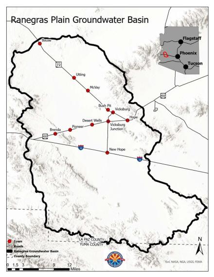
Chief Hydrologist Ryan Mitchell presented a summary of hydrology information the Department said it relied upon in advising the Director. The presentation described the Ranegras Plain basin as roughly 912 square miles in western Arizona, with low rainfall on the valley floor and higher rainfall in the surrounding mountains. The Department cited long-term average precipitation of about 5.5 inches per year on the valley floor and about 8.5 inches per year in nearby mountain areas.
On inflows, the Department highlighted several estimated components:
- Mountain front recharge estimated at about 2,000 acre-feet per year.
- Basin-to-basin underflow described as limited, with less than 1,000 acre-feet per year coming from Butler Valley and less than 1,000 acre-feet per year exiting to the north.
- Central Arizona Project canal leakage estimated at roughly 2,500 acre-feet per year in the basin area.
On outflows, the presentation identified groundwater pumping as the dominant driver. It cited agricultural pumping of about 40,000 acre-feet per year since 2016, industrial pumping of about 1,600 acre-feet per year, and smaller domestic pumping.
Mitchell also described groundwater level declines and land subsidence:
- Example monitoring wells showed declines ranging from a few dozen feet over many decades in some areas to more than 200 feet in about four decades in areas closer to heavy pumping.
- A contour map summarized declines from 1993 to 2022, including areas where water level change exceeded 175 feet.
- The Department reported cumulative land subsidence of about 25 to 40 centimeters (about 9.8 to 15.7 inches) from 2010 to 2025, with subsidence rates increasing over time, including a reported 2024 to 2025 rate of 3 to 5 centimeters per year (about 1.2 to 2.0 inches per year).
The Department’s closing hydrology slide characterized the basin water budget as out of balance, with observed groundwater declines and significant land subsidence.
Exempt Wells Versus Non-Exempt Wells.
A recurring topic in public comments was how regulation might affect households and small landowners. The Department presentation drew a sharp distinction between exempt and non-exempt wells in an Active Management Area. It stated that an exempt well must meet all three conditions: a pump capacity of 35 gallons per minute or less, use less than 10 acre-feet per year for non-irrigation purposes, and not be used to irrigate two or more acres. Wells meeting those criteria are exempt from obtaining a grandfathered right or withdrawal authority, exempt from measuring and reporting withdrawals, and exempt from conservation requirements in a management plan.
By contrast, the presentation stated that within an Active Management Area, wells pumping more than 35 gallons per minute are required to meter and report annual water use, and non-exempt users generally must have a recognized withdrawal authority.
Public Comments Showed a Basin Divided.
During the comment period, speakers voiced sharply different concerns and priorities. Several themes emerged:
- Food and farming versus water limits. Some speakers argued that agriculture is essential to local and statewide food supply and the local economy, and warned that new limits could push farming out and reduce economic activity. Other speakers questioned whether current cropping choices in a desert basin are sustainable, including comments that some forage production is exported rather than used locally.
- Property value and development concerns. Some landowners and local officials warned that new regulatory requirements could reduce property values or make subdivision harder, especially if future development must demonstrate a 100-year assured water supply. Others argued that doing nothing could also depress values if wells fail and land subsidence worsens.
- Trust and control. Multiple speakers expressed distrust that decisions made in Phoenix would prioritize local needs. Several urged that any governing structure should include strong local representation. Others said state action is necessary because, in their view, local governance has not produced a workable groundwater plan.
- What an Active Management Area can and cannot do. Supporters described an Active Management Area as a tool to create structure, require measurement, and build a management plan over time. Critics described it as a “water grab” or a step toward more regulation on residents.
What Happens Next and When.
Under the Department’s process description, the Director must issue written findings within 30 days after the public hearing, and the Department timeline indicated the decision and findings would be issued no later than January 17, 2026. If the Director designates an Active Management Area, the irrigation expansion prohibition remains in effect, and additional regulatory steps follow on set timelines, including development of a management goal and a management plan. If the Director does not designate an Active Management Area, the irrigation expansion prohibition is lifted.
The Department also stated that written comments not presented at the hearing could be submitted until midnight on Friday, December 19, 2025. Written comments are published on ADWR’s website.

Truth.