
- Southern Arizona lost groundwater at double the previous decade’s rate.
- Total basin losses equal the full capacity of Lake Mead.
- Agriculture and La Niña cycles contributed to the decline.
- Some areas showed improvement under groundwater management rules.
Friday, July 25, 2025 — A newly released analysis from NASA’s Earth Observatory and Arizona State University paints a stark picture of Arizona’s underground water reserves that echoes a study published by Nature’s Communications Earth and Environment in April. Between 2002 and 2024, the Colorado River Basin—an essential water source for about 40 million people across the Southwest, lost an estimated 27.8 million acre-feet of groundwater. That amount rivals the total storage capacity of Lake Mead, the nation’s largest reservoir.
NASA’s findings , based on satellite measurements from the Gravity Recovery and Climate Experiment (GRACE) and its follow-on mission, show that the situation has worsened in recent years. From 2015 through 2024, the rate of groundwater loss in parts of western and southeastern Arizona more than doubled. Areas in La Paz, Mohave, and Cochise counties saw declines reaching 12 millimeters (0.5 inches) per year, compared to 5 millimeters annually during the previous decade.
Main Drivers: Climate and Crops.
Researchers attribute the worsening losses to two main factors. First, shifting climate patterns played a significant role. A strong El Niño event from 2014 to 2016 gave way to a multi-year La Niña period, including a rare “triple-dip” La Niña between 2020 and 2023. These conditions typically bring drier winters to the Southwest, which limits natural aquifer recharge.
Second, the expansion of industrial agriculture intensified demand on already-stressed groundwater supplies. Large-scale alfalfa farms in La Paz County, along with dairies, cotton fields, pecan orchards, and other water-intensive crops in Maricopa, Pinal, and Cochise counties, contributed to the rising drawdown. According to Arizona’s Department of Water Resources, irrigated agriculture uses approximately 72 percent of the state’s available water. Much of this irrigation is still done using flood techniques, which are cheaper but far less efficient than modern drip or sprinkler systems.
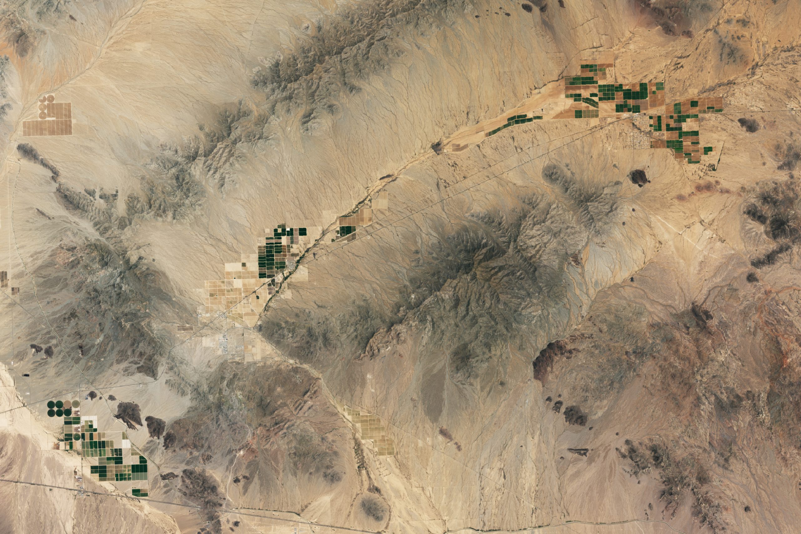
A Desert Seen From Space.
A July 12, 2025 satellite image from Landsat 8 shows the contrast vividly. Patches of green farmland—some growing alfalfa, others fruits and vegetables—dot the desert near Vicksburg, Wenden, and Aguila in La Paz and Maricopa counties. While some fields in Butler Valley have gone fallow due to lease terminations and pumping concerns, the broader landscape still reflects heavy agricultural use in one of the driest regions of the country.
Policy Interventions Show Promise.
Despite the grim statistics, the study’s authors found reasons for cautious optimism in areas governed by Arizona’s Groundwater Management Act of 1980. Regions designated as active management areas (AMAs) or irrigation non-expansion areas (INAs) showed comparatively smaller losses. A newly designated AMA in the Willcox Basin, established in 2025, may offer a model for curbing groundwater depletion if similar regulations are applied more broadly.
“The depletion of groundwater far outpaces the surface water losses,” said Karem Abdelmohsen, the study’s lead author. “This is a big warning flag.”
New Tools for Smarter Farming.
NASA is also backing technological solutions. One such effort is OpenET, a satellite-based platform that helps farmers estimate how much water crops and soil actually release into the atmosphere. By using tools like OpenET, growers can align irrigation more closely with plant needs, reducing waste and improving efficiency across the board.
As both policymakers and water users confront Arizona’s declining aquifers, the challenge will be balancing the demands of agriculture, cities, and the environment before more of the state’s water disappears underground.
SOURCE (and Image):
NASA Earth Observatory, July 21, 2025
Full report: https://earthobservatory.nasa.gov/images/154567/arizonas-declining-groundwater