- New University of Nebraska map shows state-by-state differences.
- Researchers clarify how water laws shape drought and policy decisions.
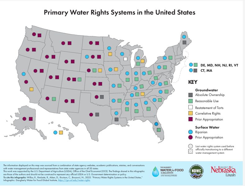
- Tool highlights surface and groundwater rights across the nation.
Wednesday, October 8, 2025 — A new map from the University of Nebraska offers a clear visual representation of how water rights systems vary across the United States. The map was developed by researchers from the Daugherty Water for Food Global Institute, the National Drought Mitigation Center, and the Department of Agricultural Economics. Released October 2, 2025 , the University and its partners say it is the first thematic map of its kind to outline primary surface and groundwater rights nationwide.
A Tool for Smarter Water Governance.
Water rights define who can use water, when, and how much—fundamental questions in every aspect of water management. According to the research team, understanding these systems is essential when developing or evaluating policies related to irrigation, drought response, water transfers, and interstate water management.
The new map shows that western states generally operate under the prior appropriation system, where water rights are based on seniority rather than land ownership—often summarized as “first in time, first in right.” In contrast, most eastern states follow common law principles, granting landowners the right to use water that flows through or borders their property.
How the Map Was Created.
To build the map, researchers gathered information from state agencies, statutes, academic publications, and interviews with water professionals in all 50 states. This approach ensured accuracy and regional representation. The project was funded by the U.S. Department of Agriculture’s Office of the Chief Economist.
The research team anticipates that the map will inform future studies and enable policymakers and landowners to better understand how water laws impact management decisions, particularly as drought and groundwater depletion persist as challenges to the nation.
About the Partners.
Daugherty Water for Food Global Institute (DWFI):
Founded in 2010, DWFI focuses on achieving food and water security by promoting scientific and policy-based solutions that allow for greater food production with less water. Its work combines research, education, and outreach on a global scale.
National Drought Mitigation Center (NDMC):
Established in 1995, the NDMC helps decision-makers anticipate and reduce the effects of drought. The center collaborates with local to international partners and also manages the U.S. Drought Monitor.
Department of Agricultural Economics, University of Nebraska–Lincoln:
Since 1914, the department has contributed to agricultural and resource policy through research, teaching, and outreach. Its faculty and students study rural development, resource allocation, and agricultural economics.
Image: Screenshot of the University of Nebraska’s Primary Water Rights Systems map.
FAQ
Q: What does the new map show?
It depicts each state’s primary water rights system for both surface and groundwater, showing where prior appropriation or common law applies.
Q: Why is this important?
Understanding water rights helps decision-makers create fair and effective policies for water allocation, drought response, and conservation.
Q: Who created the map?
The map was developed by the Daugherty Water for Food Global Institute, the National Drought Mitigation Center, and the Department of Agricultural Economics at the University of Nebraska–Lincoln.
Q: How was the information collected?
Researchers used official state data, academic sources, and direct communication with water agency professionals from all 50 states.
Q: Who funded the project?
Funding came from the U.S. Department of Agriculture’s Office of the Chief Economist.
Q: Where can the map be viewed?
The map is available through the University of Nebraska’s Daugherty Water for Food Global Institute website.