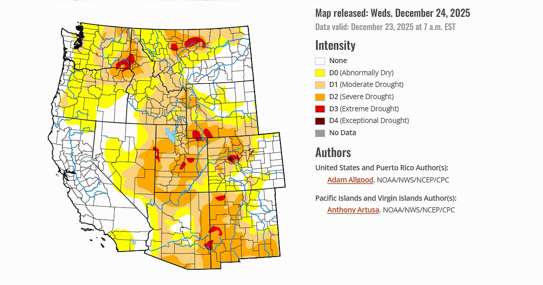
- Much of the western United States remained dry and warmer than normal during the week ending December 23, 2025.
- Early winter storms brought rain to some regions, but snowpack gains were limited at higher elevations.
- Conditions across the Colorado River Basin showed continued stress, with drought persisting or expanding in several areas.
Saturday, December 27, 2025 — The United States Drought Monitor report issued December 24, 2025 , describes a country experiencing sharp contrasts in weather and water conditions. While portions of the Pacific Northwest received repeated rounds of heavy precipitation, much of the rest of the western and central United States remained under a persistent ridge of high pressure that suppressed rainfall and promoted unusually warm temperatures.
In the eastern United States, several storm systems delivered widespread precipitation, but warmer conditions caused much of it to fall as rain rather than snow. Frozen soils and slow-responding groundwater limited the benefits of this moisture, resulting in only modest drought improvements in select areas.
By contrast, large portions of the West and High Plains saw little to no precipitation, with above-normal temperatures accelerating winter drought impacts that are more typical of spring.
Colorado River Basin: Dryness Holds Firm.
Across the seven Colorado River Basin states—Arizona, California, Colorado, Nevada, New Mexico, Utah, and Wyoming—the overall picture remained concerning. The dominant weather pattern favored dry conditions across the Southwest and interior West, limiting opportunities for meaningful drought relief.
Atmospheric river storms brought significant precipitation to northern California and parts of the Pacific Northwest, but above-normal temperatures kept snow levels high. As a result, much of the moisture fell as rain rather than snow, reducing storms’ ability to build early-season snowpack in the Sierra Nevada and Rocky Mountains. Snow water equivalent values remained well below average in several key mountain ranges that supply runoff to the Colorado River system.
Snowpack Concerns at Higher Elevations.
While winter snowpack is not an immediate drought indicator, it plays a critical role in spring and summer water supplies. During the past week, snow accumulation lagged across the Cascades, northern Sierra Nevada, and portions of the Rockies due to warm storm temperatures. In some areas, snow water equivalent remained below half of the average for late December.
These conditions led drought officials to maintain existing drought classifications across higher elevations, even as some lower-elevation areas experienced short-term moisture benefits.
Interior Basin States See Deterioration.
Dry weather and unseasonably warm temperatures contributed to drought degradation in parts of Colorado and Wyoming. In western Colorado, exceptional drought was introduced in portions of Eagle and Pitkin Counties, reflecting worsening impacts tied to limited snow cover and persistent dryness. Across Wyoming, areas of abnormal dryness expanded on the plains as strong winds and a lack of snow cover increased soil moisture loss.
Elsewhere in the basin, drought conditions generally persisted without improvement. The continued absence of widespread precipitation across Arizona, Nevada, New Mexico, and Utah left existing drought designations unchanged.
Looking Ahead.
According to outlooks referenced in the report, additional atmospheric rivers were expected to bring moisture into California and parts of the interior West after the reporting period. However, sustained warmth could continue to limit snowpack recovery at higher elevations unless colder conditions develop.
For now, the Colorado River Basin remains vulnerable as winter progresses, with snowpack development emerging as a key factor to watch in the months ahead.