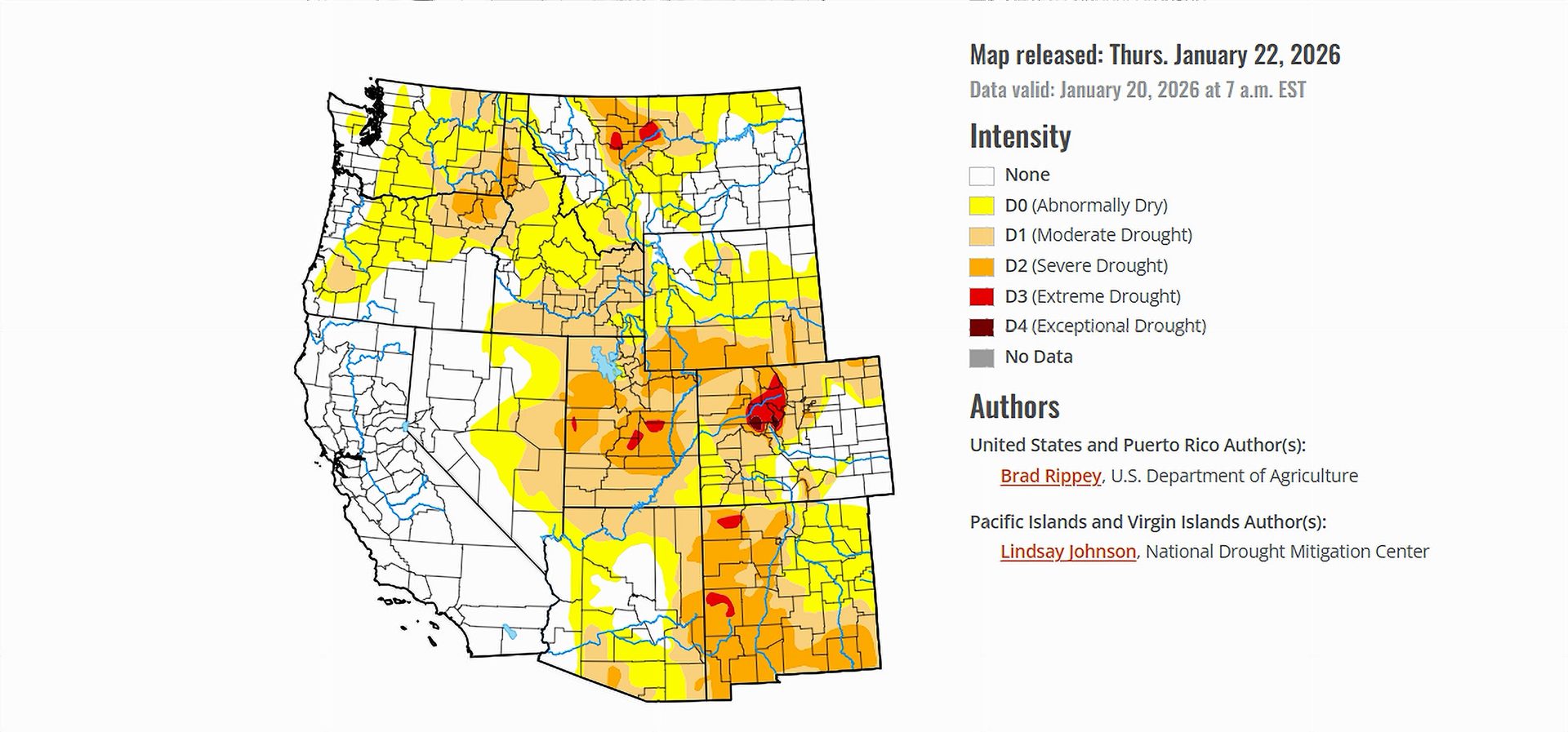
- Drought conditions across the United States remained largely unchanged as of January 22, 2026.
- Snowpack levels are lagging in many Western watersheds despite earlier winter precipitation.
- Colorado River Basin storage remains well below average heading into late January.
- Forecast snowstorms could alter drought indicators in coming weeks.
Saturday, January 24, 2026 — As of the latest Drought Monitor Report released on Thursday, drought conditions across the continental United States reflect a pause rather than a turning point. A shift in weather patterns brought calmer conditions to much of the West and colder, stormier weather to the East. This transition slowed the pace of recent changes to drought classifications, leaving many areas essentially “frozen in place” on the national drought map.
While parts of the country experienced rain or snow earlier in the winter, recent weeks have been generally drier across large portions of the West. At the same time, persistent cold across the Midwest and East limited evaporation and soil moisture loss, preventing rapid drought expansion. The result was a largely stable national drought footprint, even as concerns about spring and summer water supplies continue to build.
Western Water Supplies: Snow Matters More Than Rain.
In the West, the dominant issue is not how much precipitation has fallen, but how it arrived. Many winter storms this season were warmer than average, delivering rain rather than snow at elevations where mountain snowpack typically builds. Snow-water equivalency—the amount of water stored in snowpack—was already below average in many Western basins by mid-January.
This matters because snowpack functions as the region’s largest natural reservoir, releasing water gradually during spring and early summer. Even where total precipitation has been above average, reduced snowpack raises questions about runoff timing, summer streamflows, and wildfire risk.
California stands out as an exception in terms of reservoir storage. As 2026 began, the state’s primary reservoirs held roughly 25.9 million acre-feet of water, well above historical averages. However, this relatively strong position does not eliminate broader regional concerns tied to snowpack deficits and warming winter conditions.
Colorado River Basin: Long-Term Strain Remains.
The Colorado River Basin continues to reflect long-standing water stress. Total storage across the basin stood just under 17.3 million acre-feet as of January 22, representing about 53 percent of the historical average. This figure underscores the cumulative effects of prolonged drought, elevated temperatures, and sustained water demand across Arizona, California, Colorado, Nevada, New Mexico, Utah, and Wyoming.
Snow-water equivalencies across much of the basin were below normal, particularly in the Southwest. Only parts of the northern Rocky Mountains were reporting near-normal snowpack conditions. Although some early-season storms delivered substantial moisture, the lack of consistent cold conditions limited snow accumulation in key headwater areas.
More than half of the broader Western region, including all of California, remained free of drought classification at the time of the report. Still, the Colorado River Basin’s below-average storage highlights the system’s vulnerability, especially as it approaches the latter half of the snow-accumulation season.
Why the Next Storms Matter.
The drought snapshot released on January 22 captures conditions before a significant round of winter storms expected to move across the Rockies, Plains, and parts of the South beginning January 23. These storms have the potential to bring widespread snow, ice, and cold temperatures, particularly in southern portions of the Rockies and Plains.
If colder conditions dominate during these storms, mountain snowpack in portions of the Colorado River Basin could improve, potentially changing future drought assessments. However, the full hydrologic impact will depend on storm intensity, snow-to-rain ratios, and the duration of colder temperatures.
Drought maps are updated weekly, and the upcoming storms may prompt adjustments to snowpack measurements and water supply indicators in subsequent reports. For now, the January 22 assessment reflects a West in pause mode—neither rapidly improving nor sharply deteriorating—while the Colorado River Basin remains constrained by long-term water deficits.