- Much of the western United States remains drier than normal heading into February.
- Snowpack across the Colorado River Basin is well below seasonal averages.
- Low snow accumulation is paired with dry soils and reduced streamflows.
- Only limited, localized improvements were observed within the basin.
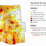
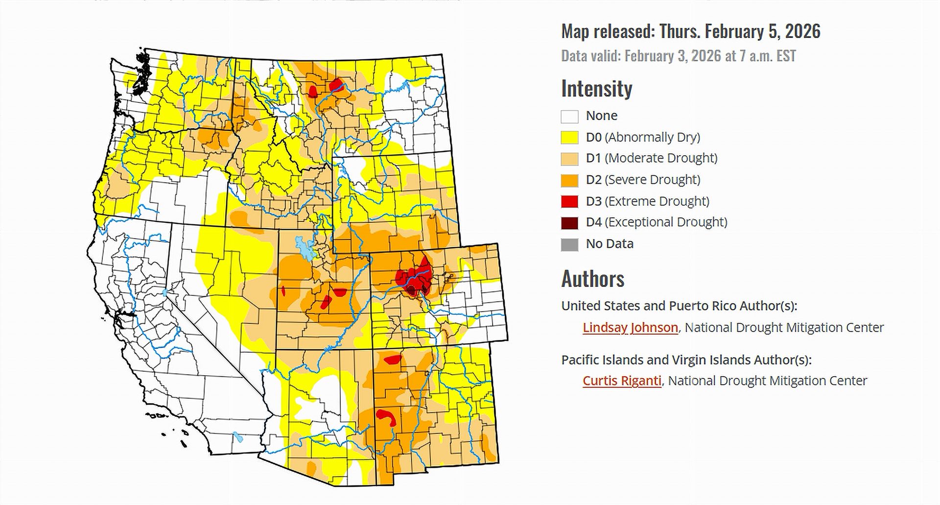
Saturday, February 7, 2026 — As of early February 2026, drought conditions remain widespread across large portions of the United States, according to the U.S. Drought Monitor released on February 5 . Precipitation during the past week was scarce across much of the country, with many regions receiving less than one-quarter of their typical rainfall for this time of year. While localized storms brought snow or mixed precipitation to parts of the Midwest, Northeast, and Southeast, these events were not enough to meaningfully reverse longer-term moisture deficits.
In the western United States, above-normal temperatures combined with limited and uneven precipitation continued to undermine winter snowpack development. Even where snowfall occurred, accumulations often failed to keep pace with what is normally expected by early February. As a result, snowpack, soil moisture, and streamflow conditions worsened across much of the region.
Colorado River Basin: A Deepening Snow Drought.
The seven Colorado River Basin states—Arizona, California, Colorado, Nevada, New Mexico, Utah, and Wyoming—remain firmly affected by what drought analysts describe as a deepening snow drought. Snowpack across much of the basin is significantly below seasonal norms, a critical concern given the river system’s heavy reliance on mountain snow as its primary water source.
Snow water equivalent, which measures how much water is contained in the snowpack, continues to lag well behind median levels across the basin’s headwaters. Monitoring sites show many locations reporting values far below what is typical for early February. In some mountain areas, snowpack levels are among the lowest observed for this point in the winter season.
These deficits persist despite occasional snowfall because recent storms have generally produced modest amounts that have not offset earlier shortfalls. Above-normal temperatures across much of the interior West have further limited snow accumulation and increased evaporation from already dry soils.
Compounding Impacts: Soils and Streamflows.
The snowpack shortfall is being compounded by declining soil moisture and below-normal streamflows across the Colorado River Basin. Dry soils reduce the ability of future precipitation or snowmelt to efficiently recharge rivers and reservoirs. Streamflows in many areas remain below normal, reflecting both the lack of recent precipitation and the cumulative effects of prolonged dryness.
Conditions deteriorated across parts of Utah, Colorado, Wyoming, and Nevada during the past week as these indicators continued to trend downward. While southern New Mexico experienced some lingering benefits from earlier storms, those improvements were localized and did not substantially alter basin-wide conditions.
What’s Predicted.
Forecasts included in the Drought Monitor indicate the potential for more widespread precipitation across parts of the western United States in the coming days, particularly in the Pacific Northwest and northern and central Rockies. However, farther south across much of the Colorado River Basin, precipitation is expected to be more scattered, with many areas receiving little or no moisture.
Temperature outlooks favor above-normal warmth across much of the interior West, a factor that could continue to limit snowpack recovery even if storms do materialize. As of early February, the Colorado River Basin remains vulnerable, with winter conditions so far falling short of what is typically needed to rebuild water supplies ahead of the spring runoff season.