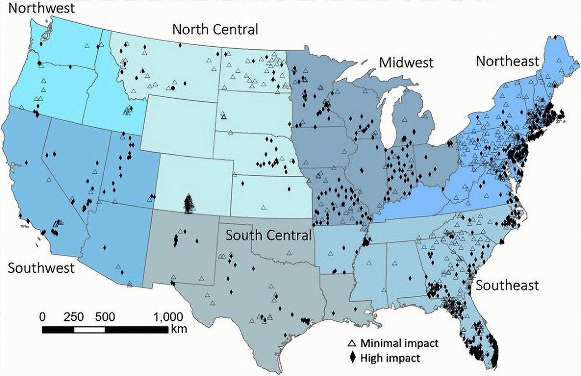
- A February 2026 national study analyzed groundwater drought using 1,510 monitoring wells from 2001–2020.
- Drier regions, including the Southwest, tended to have longer and more severe groundwater drought events than wetter regions.
- From 1981–2020, many wells in the Northeast showed rising groundwater levels, while parts of the Southeast showed declines.
- Satellite-model drought estimates from the GRACE mission often did not match drought trends measured directly in wells.
- Researchers said more long-term monitoring wells are needed, especially in western states with major data gaps.
Friday, February 27, 2026 — Groundwater is the water stored underground in aquifers, the water-bearing layers of sand, gravel, or rock that feed wells and also help support streams, springs, wetlands, and wildlife. “Groundwater drought” happens when underground water levels stay unusually low for long enough that water supplies, ecosystems, and water costs can be affected.
The February 2026 study in the Journal of Hydrology explains that groundwater drought can raise pumping costs, reduce water that normally flows from aquifers into rivers and wetlands, harm crops, worsen water quality, and contribute to land subsidence in some areas. The paper also notes that drought can start with low precipitation and then move through the system over time, eventually lowering groundwater recharge.
What the study looked at.
Researchers led by U.S. Geological Survey scientists examined groundwater drought across the contiguous United States using two main sources:
1) Real well measurements.
The team compiled groundwater-level records from U.S. Geological Survey databases, including the National Water Information System and the National Ground Water Monitoring Network. The study relied on long, consistent records and screened out wells that did not meet strict data-quality rules.
2) Satellite and model estimates.
The study compared well results to a drought-monitoring product that blends NASA’s GRACE satellite data with a land-surface model. GRACE tracks changes in Earth’s gravity field, which can reflect changes in total water storage across large areas. The product used in the study, called GRACE Drought Monitor Data Assimilation, produces weekly estimates on a grid of about 12 kilometers.
The researchers also classified wells as likely “minimal” or “high” human impact using a statistical model informed by land use and other factors, then reviewed by groundwater specialists.
Key finding #1: Drier regions tended to have longer groundwater droughts.
Using well data from 2001–2020, the study found that longer-lasting and more severe groundwater drought events were more common in drier regions such as the Southwest than in wetter regions such as the Northeast. Western regions also tended to show more year-to-year variability in groundwater drought metrics than eastern regions.
In simple terms, wetter areas often experience shorter groundwater drought events, while drier areas can experience droughts that last longer underground and vary more from place to place.
Key finding #2: Long-term trends split the country, with Northeast improving and parts of the Southeast worsening.
For a longer view, the study analyzed 613 wells with strong records from 1981–2020. The results showed a mixed national picture, but with clear regional patterns:
-
Northeast: Many wells showed increasing groundwater levels over time, along with decreasing drought duration and severity, which the study describes as consistent with “wetter conditions” in groundwater terms.
-
Parts of the Southeast: Many wells showed decreasing groundwater levels and increasing groundwater drought metrics, which points toward “drier conditions” underground in those locations.
The paper also notes that the national dataset is uneven, with many western areas lacking enough long-term wells to confidently map 40-year groundwater drought trends.
Key finding #3: Satellite-model drought trends often did not match what wells recorded.
One of the most practical takeaways for water managers is that groundwater drought trends derived from GRACE-based modeling often diverged from trends measured directly in wells, sometimes sharply.
The study reported very low agreement in trend direction at individual locations when comparing well-based trends to GRACE Drought Monitor Data Assimilation trends from about 2003–2020. In some regions, the satellite-model product suggested groundwater drought was getting worse while nearby wells suggested the opposite.
The researchers offered several reasons this can happen:
-
Scale mismatch: A grid cell about 12 kilometers wide can miss local groundwater differences that a single well records.
-
Depth and aquifer type mismatch: The GRACE-based product represents shallow, unconfined groundwater storage, while many monitoring wells measure different depths and sometimes confined aquifers, where water levels behave differently because of pressure conditions.
-
Local pumping and geology: Groundwater can vary dramatically over short distances due to pumping patterns, well depth, geologic barriers, and other local conditions.
Why this matters for the future.
The study’s results point to a practical warning and a practical need.
A warning about over-relying on broad-scale drought tools.
Remote sensing can be extremely useful for regional tracking, but the study found it can be unreliable for local decision-making in many places. That matters because groundwater decisions are often local: a town wellfield, a farming area, or a specific aquifer zone.
A need for more long-term monitoring wells, especially in the West
The paper emphasizes that large gaps in long-term, quality-assured monitoring data make it harder to understand groundwater drought across the country, particularly in western regions. The researchers said expanded monitoring networks would better capture where groundwater drought is worsening, where it is easing, and where conditions vary sharply across small areas.
The Take Away.
The February 2026 study shows that groundwater drought in the United States is not a single, uniform story. It varies by region, aquifer type, and even by nearby wells. It also shows that satellites and models are helpful tools, but they do not replace on-the-ground measurements when communities and water managers need dependable local information.
Source: “Groundwater drought in the United States: spatial and temporal variability,” Journal of Hydrology (February 2026), by Glenn A. Hodgkins, Caelan E. Simeone, Melissa A. Lombard, Todd G. Caldwell, John C. Hammond, Michael E. Wieczorek, and Robert W. Dudley (DOI: 10.1016/j.jhydrol.2026.135180).