
- Drought conditions expanded across much of the West this week.
- Snowpack in key mountain basins remains well below normal.
- Above-normal temperatures have limited snow accumulation in parts of the interior West.
- The Colorado River Basin continues to show expanding dryness and hydrologic stress.
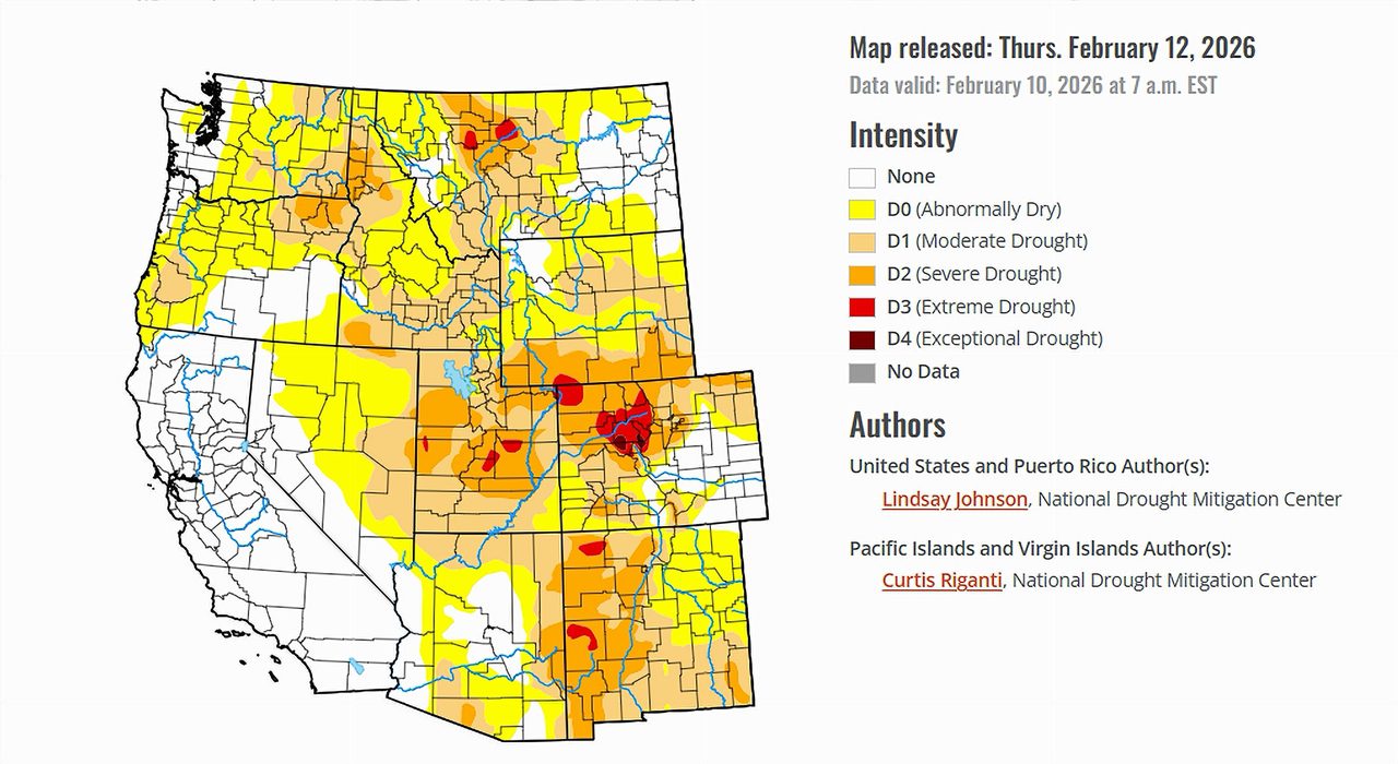
Saturday February 14, 2026 — The latest United States Drought Monitor report , released February 12, 2026, shows that drought conditions worsened in several regions of the country. Much of the Lower 48 states and Alaska experienced degradations, meaning drought intensified or expanded.
Across large sections of the country, precipitation was light and uneven. Many areas missed meaningful rainfall or snowfall, leading to growing short-term precipitation deficits. At the same time, temperatures varied sharply. The eastern half of the country experienced below-normal temperatures, while much of the West saw warmer-than-normal conditions.
The combination of limited precipitation and warmth in parts of the West has slowed snow accumulation and contributed to expanding drought conditions in critical watersheds.
Colorado River Basin: A Troubling Snow Season.
The primary concern for the seven Colorado River Basin states — Arizona, California, Colorado, Nevada, New Mexico, Utah, and Wyoming — remains snowpack and ongoing precipitation deficits.
Most low-elevation areas in California, Nevada, Arizona, Utah, and western Colorado received little to no measurable precipitation during the week. Seven-day totals were generally less than one-half inch. While some mountain snow fell in portions of the northern Rockies, accumulations were described as light and patchy.
Snowpack levels, measured by snow water equivalent, remain well below normal at many monitoring sites. Much of Wyoming and western Colorado is reporting snow water equivalent values below the 15th percentile for this time of year, with many sites in the single digits. Across Utah and Nevada, very low snowpack conditions are also being reported.
Colorado’s snowpack has been described as particularly concerning. Many monitoring stations in the central Rockies are reporting snow water equivalent levels below the 10th percentile. According to the Drought Monitor report, Colorado is experiencing its worst snowpack-to-date on record.
Snowpack is critical to the Colorado River system because it acts as a natural reservoir. Mountain snow slowly melts in spring and summer, supplying water to rivers, reservoirs, farms, and cities throughout the Basin. When snowpack is significantly below normal, less runoff is expected during the spring melt season.
Warming Temperatures Add Pressure.
Temperatures were above normal across broad areas of the interior West, including central and eastern Wyoming and northern Colorado. Daytime highs ran 5 to 15 degrees above average at times.
Warmer conditions limited snow accumulation in some basins and contributed to surface drying where snow cover was sparse. In areas without sustained snow cover, soils continued to lose moisture.
The report also notes persistent precipitation deficits over the past two to four months across Utah, Nevada, and western Colorado. These short- to mid-term deficits, combined with low soil moisture and very low snowpack, led to further drought degradations in parts of the Basin.
Eastern Wyoming and Colorado: Expanding Drought.
In eastern Wyoming and eastern Colorado, precipitation deficits deepened following another mostly dry week. Soil moisture percentiles declined, and recent above-normal temperatures led to additional drying.
As a result, areas of moderate drought and severe drought expanded across portions of eastern Wyoming and Colorado. The broader High Plains region, which connects hydrologically and climatologically to parts of the Basin, also experienced worsening conditions.
What the Next Week May Bring.
The Drought Monitor’s outlook indicates that a more active precipitation pattern is forecast for parts of the western United States over the next five to seven days, including California, the Great Basin, and the central and northern Rockies. Liquid-equivalent precipitation totals of one to three inches are expected in some areas, with locally higher amounts in favored terrain.
The Climate Prediction Center’s six- to ten-day outlook favors above-normal precipitation across much of the western United States, including California, the Great Basin, and the northern and central Rockies. At the same time, below-normal temperatures are favored along much of the West Coast and portions of the Great Basin.
Whether this pattern delivers meaningful snow to high-elevation watersheds will be closely watched, as snowpack levels across the Colorado River Basin remain critically low for mid-February.

It depends. For instance, parts of Colorado that directly feed the Colorado River have had a snow deficit, resulting in less water for the river. That affects all of the basin states.