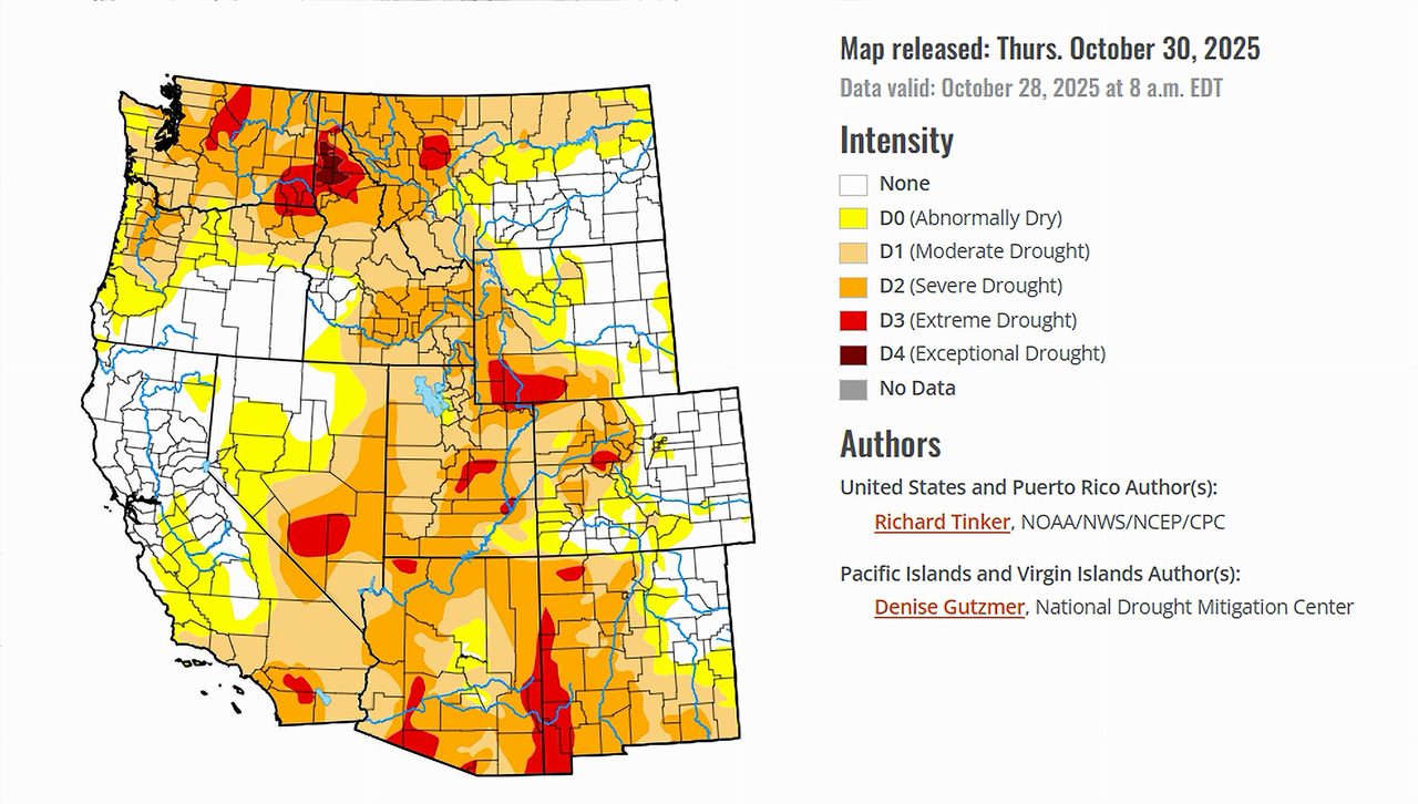
- Heavy precipitation eased drought across parts of the Pacific Northwest and Texas.
- Conditions in Arizona, Utah, Nevada, and New Mexico remained mostly unchanged.
- The Colorado River Basin still faces widespread dryness in higher elevations.
- Despite the federal government shutdown, the U.S. Drought Monitor map and its associated products remain unaffected and continue to be released on schedule.
Saturday, November 1, 2025 — As of October 30, 2025, the U.S. Drought Monitor reported that widespread rainfall brought some improvement to drought conditions across portions of the nation, particularly from the Pacific Northwest to Texas. The heaviest rainfall, between three and ten inches, was observed in higher elevations and coastal areas stretching from northern California to Washington, as well as parts of Oklahoma, Texas, and the Gulf Coast.
These storms led to “significant areas of improvement” in many regions, including the northern Intermountain West, the Great Plains, and parts of the Southeast and Midwest. However, drought continued or worsened in pockets of the northern High Plains, Texas Panhandle, Deep South, and coastal Southeast.
Nationwide, coverage of abnormal dryness (D0 or worse) declined slightly to 69 percent of the contiguous United States, while drought (moderate drought or worse) dropped to 43.6 percent—both figures still notably above the 25-year average.
Conditions Across the Colorado River Basin.
The seven states of the Colorado River Basin—Arizona, California, Colorado, Nevada, New Mexico, Utah, and Wyoming—experienced mixed results during the past week, according to the Drought Monitor.
Arizona and New Mexico.
Conditions across Arizona and New Mexico held steady, with no notable changes from the previous week. Both states remain largely dry, and many higher elevation regions continue to experience moderate to severe drought (D1–D2). Despite the absence of widespread rain, no new areas of deterioration were introduced.
Utah and Nevada.
In Utah and Nevada, drought patterns also persisted with little variation. Much of Utah’s central and southern regions remain in abnormally dry (D0) status, while western and southern Nevada continue to show moderate drought (D1). Northern sections, however, benefited from cooler temperatures and some modest improvement.
Colorado and Wyoming.
The Drought Monitor described the High Plains Region, which includes Colorado and Wyoming, as “the least-affected by dryness and drought” compared with other areas of the country. Still, about 55 percent of those two states combined are experiencing some level of dryness, and roughly one-third remain under drought categories ranging from moderate to severe.
Moderate to locally heavy rainfall in northwestern Wyoming helped improve conditions in some basins, while south-central Colorado saw limited relief and even minor deterioration in isolated areas.
California.
Across northern California, heavy precipitation produced measurable improvement, especially along the coast and in higher elevations of the Sierra Nevada. Some areas recorded more than 3 inches of rainfall, with localized totals exceeding 8 inches in parts of northwestern Washington and northern California. However, southern and inland California saw little change.
The Broader Western Picture.
The Drought Monitor reported that “conditions generally persisted across all but the northern tier of the West Region.” This means that while the Pacific Northwest saw improvement, most of the interior West—New Mexico, Arizona, Utah, Nevada, and much of California—remained unchanged.
Overall, the drought across the Colorado River Basin remains entrenched but stable, with no significant expansion or contraction. While early-season precipitation in the Pacific Northwest offers optimism for future snowpack accumulation, the basin’s long-term recovery continues to depend heavily on winter snowfall and spring runoff.
What’s in the Forecast?
Between October 30 and November 3, the forecast calls for mostly dry weather across much of the western United States. Light to moderate precipitation is expected only in the higher elevations of the Intermountain West and along the Oregon and Washington coasts.
For November 4–8, wetter-than-normal conditions are expected to return to the Pacific Northwest, potentially expanding southward into northern California and the northern Great Basin. In contrast, New Mexico and western Texas face a higher risk of drier-than-normal weather. Temperatures are likely to trend warmer than average across the Rockies and much of the West, which could slow early snowpack formation.
Final Note.
Despite the ongoing federal government shutdown, the U.S. Drought Monitor has confirmed that “the U.S. Drought Monitor map and its associated products remain unaffected and will continue to be released on schedule.”