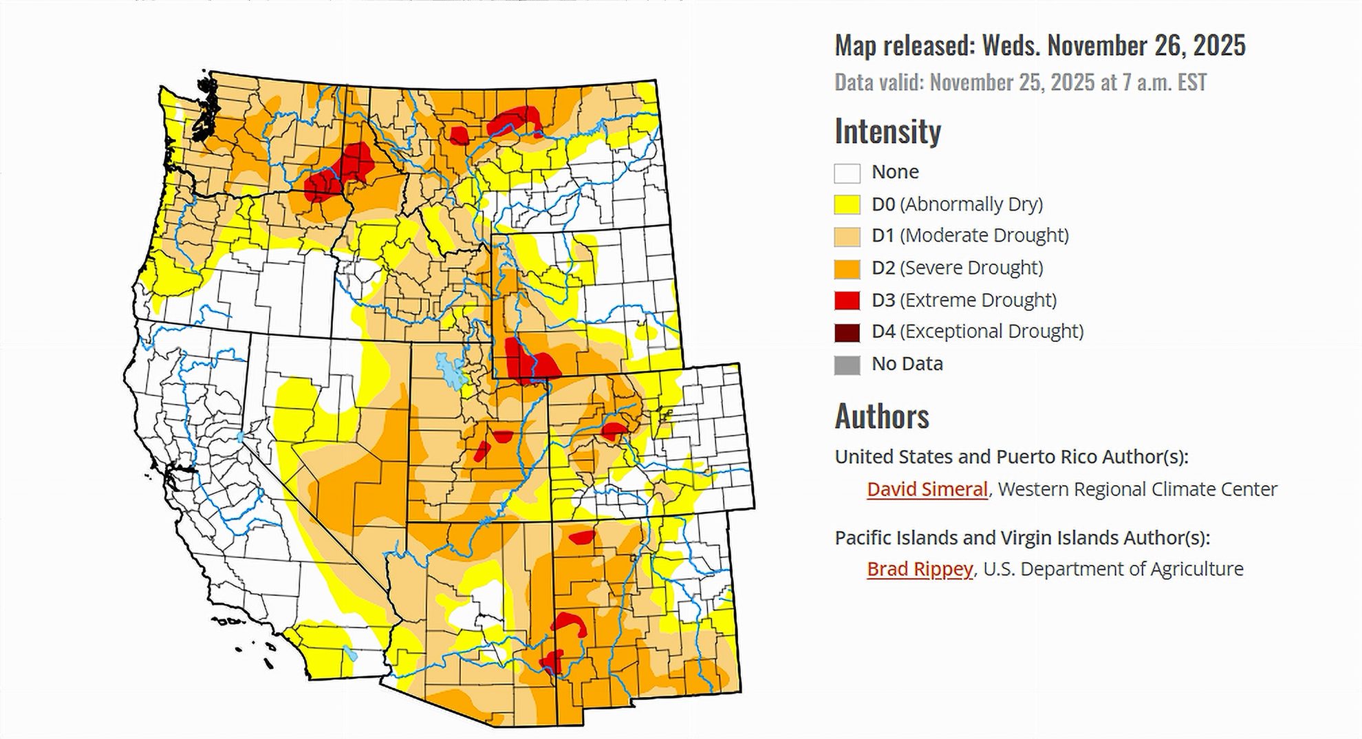
- Recent storms improved drought across Arizona, Southern California, and the Four Corners.
- Reservoir storage remains mixed, with strong conditions in California but low levels on the Colorado River.
- Snowpack improved in the southern ranges but remains below normal across much of the Intermountain West.
- Drought eased in parts of the nation, though dryness persisted in the Southeast and Pacific Northwest.
Saturday, November 29, 2025 — The latest United States Drought Monitor, released on November 26, 2025, shows widespread improvements in drought conditions across several regions of the country. Much of the West benefitted from a series of early-season storms, while parts of the Lower Midwest and Northeast saw gains from timely rainfall. In contrast, drought continued to intensify in portions of the Southeast, where warm and dry weather remained firmly in place.
Across the West, the most notable change occurred in the Desert Southwest, where storms boosted precipitation totals that have been building since October. California’s early wet season further strengthened reservoir recovery, while lingering dryness held on in the Pacific Northwest. Elsewhere, mixed conditions prevailed: Texas saw localized improvements, the Upper Midwest experienced record dryness, and small areas of the Northeast reported modest relief.
With the publication date of this article being November 29, some local conditions may have already shifted. However, the November 26 report provides a valuable snapshot of where the country stood heading into the final month of the year.
Colorado River Basin Overview.
The seven states that depend on the Colorado River—Arizona, California, Colorado, Nevada, New Mexico, Utah, and Wyoming—experienced a generally positive week. Storms brought widespread precipitation, and several areas saw their drought categories improve. Even so, long-term water supply challenges remain visible in reservoir levels, which continue to trail the highs of the previous year.
Arizona.
Arizona saw some of the most significant drought relief in the West. Storms over the past several weeks contributed to substantial improvements across the state, and many locations have recorded near-record or record precipitation since October 1. Flagstaff, for example, is more than five inches above normal. Snowpack increases on the San Francisco Peaks and along the Mogollon Rim added further benefits.
Reservoir levels, however, show a more mixed picture. The Salt River Project reported the Salt River system at 54 percent full and the Verde River system at 68 percent full. Together, the combined storage stands at 56 percent, down from 73 percent at this time last year.
California.
Southern California continued to rebound from earlier dryness, thanks to repeated storms and a notably wetter pattern since early autumn. These conditions led to further removal of drought classifications in the southern portion of the state.
California’s reservoir system remained a bright spot. As of November 24, Lake Shasta measured 110 percent of its historical average for the date, while Lake Oroville was at 100 percent. The strong storage reflects both recent storms and wet conditions earlier in the year.
Colorado.
Colorado received pockets of improvement, particularly in southern areas influenced by recent storm activity. Snowpack saw gains in the San Juan Mountains and other southern ranges. However, conditions were more uneven farther north, where some areas of northern Colorado experienced minor drought degradations due to persistent dryness.
Statewide, reservoir conditions on the Colorado River system continue to highlight larger regional challenges. Lake Powell remained only 29 percent full.
Nevada.
Central and southern Nevada benefited from the same storm systems that impacted California and Arizona, resulting in improvements on the drought map. Las Vegas recorded more than two inches above normal for the season, contributing to short-term dryness relief.
Despite the precipitation, the region remains tied closely to the broader Colorado River system. Lake Mead sits at 32 percent full, well below levels seen last year.
New Mexico.
Western and northern New Mexico experienced some improvements, supported by precipitation and building snowpack in the Nacimiento Mountains and portions of the northern high country.
Farther south, long-term water supply concerns continued. Elephant Butte Reservoir, the state’s largest, was only 5 percent full and 12 percent of its historical average for late November.
Utah.
Southern Utah saw modest improvement as storm systems pushed moisture into the region. Snowpack increased in the Mountains of southwestern Utah and along the central and southern ranges.
Northern Utah, by contrast, remained largely unchanged. Dryness in the Pacific Northwest extended into parts of Utah, and statewide snowpack as a whole continues to lag behind early-season norms.
Wyoming.
Wyoming’s conditions remained relatively stable, with no major changes reported this week. Snowpack in the western ranges is generally below normal, reflecting the broader regional trend of early-season deficits across the Intermountain West.
Reservoir Conditions Across the Basin.
The contrast between California’s strong reservoir storage and the Colorado River system’s low levels remains a defining feature of the season.
-
Lake Powell: 29 percent full.
-
Lake Mead: 32 percent full.
-
Total Colorado River System Storage: 37 percent of capacity (down from 42 percent at this time last year).
These numbers illustrate the long-term nature of the region’s water challenges, even as short-term drought conditions improve.
Western Snowpack Highlights.
The November storms delivered early gains to the southern half of the West. Snowpack improved in:
-
Southern and central Sierra Nevada.
-
Spring Mountains in Nevada.
-
Northern Arizona’s San Francisco Peaks.
-
Mogollon Rim in Arizona.
-
Southwestern Utah highlands.
-
Northern New Mexico ranges.
Elsewhere, much of the Intermountain West and Pacific Northwest remained behind seasonal averages for snowpack.
Looking Ahead.
The National Weather Service expects a significant winter storm to impact the Upper Midwest and Great Lakes region in the coming days. Meanwhile, the West is forecast to experience a period of relative dryness, especially across California and the Great Basin. Lighter precipitation may reach the Intermountain West, with moderate rainfall likely in western Washington.
Temperature forecasts call for below-normal readings across much of the country except for the Southeast and portions of the Pacific Coast, which may see warmer-than-normal conditions. Precipitation probabilities favor wetter-than-normal conditions across much of the continental United States, with the exception of northern California and western Oregon where drier conditions are expected.


