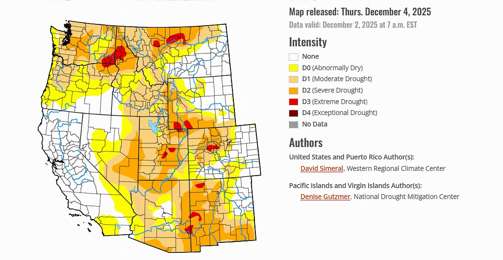
- Storms improved short-term drought in parts of California, Nevada, Utah, and Wyoming.
- Mountain snowpack remains below normal across most western ranges.
- Lower Colorado snowpack stands well above normal, but Upper Colorado lags.
Saturday, December 6, 2025 — As of December 4, 2025, the U.S. Drought Monitor shows a patchwork of improvement and concern across the United States. Recent storms helped ease dryness in several regions, including parts of the West, Plains, Midwest, South, Southeast, and Northeast.
In the Northeast, significant snowfall and recent precipitation have improved groundwater and soil moisture in some areas, but many rivers and streams still run below normal levels. The Southeast saw both relief and deterioration: rainfall brought some improvement in Alabama, northwestern Georgia, and South Carolina, while conditions worsened in Florida, east-central Georgia, central North Carolina, and southern Virginia as streamflows dropped and 30-day precipitation deficits grew.
Across the South, drought-affected parts of Texas improved following recent rains, though western Texas remained dry, and several locations in Texas, Louisiana, and Mississippi recorded one of their driest 30-day periods on record. In the Midwest and Northern Plains, snowfall brought modest relief, while cold temperatures persisted.
Within this national context, the seven Colorado River Basin states face an early winter marked by both helpful storms and lingering deficits, especially in mountain snowpack.
Snowpack: A Uneven Start to the Water Year.
The Water Year began on October 1, and by early December, the mountain snowpack remains behind across most of the West. According to the Natural Resources Conservation Service SNOw TELemetry network, as of December 2, regional snow-water equivalent shows a sharp contrast between basins:
-
Upper Colorado: 53 percent of normal
-
Lower Colorado: 121 percent of normal
-
Great Basin: 39 percent of normal
Other regions linked to western supply also lag: the Pacific Northwest sits at 43 percent of normal, the Missouri Basin at 47 percent, and the Rio Grande at 64 percent.
In California, statewide snowpack on December 3 measured just 39 percent of normal, with striking differences by region:
-
Southern Sierra Nevada: 78 percent of normal.
-
Central Sierra Nevada: 36 percent of normal.
-
Northern Sierra Nevada: 17 percent of normal.
These numbers underscore a key early-season message for the Colorado River Basin: despite some very wet pockets, much of the West has not yet built the snow reserves typically seen by early December.
Conditions in the Colorado River Basin States.
California.
The latest Drought Monitor shows continued improvement in parts of eastern California and the Mojave Desert. Recent storms, especially during November, have meaningfully boosted short-term conditions.
The National Weather Service office in Los Angeles reports that November was among the wettest in more than 50 years across southwestern California. The city of Santa Barbara recorded its wettest start to a water year on record through November, with more than 9.5 inches of precipitation. Some locations in the Santa Ynez Mountains have already received over 15 inches since October 1.
Even with these wet pockets, California’s snowpack remains well below normal overall, and the Northern Sierra stands out with particularly low snow-water equivalent. The state still depends on a strong mid-winter storm pattern to build the snow that feeds rivers and reservoirs.
Nevada.
Southern Nevada is one of the bright spots in the December 4 update. Conditions there have improved significantly since the beginning of the Water Year, with recent storms contributing to better short-term indicators such as soil moisture and streamflows.
On the drought map, west-central and southern Nevada show clear improvement. However, the broader Great Basin snowpack, which includes much of Nevada, is still only 39 percent of normal. That leaves longer-term questions about water supply unresolved as winter continues.
Utah.
Utah’s picture is split. The Drought Monitor notes improvements in southwestern Utah, driven by recent storms and better short-term hydrologic indicators. At the same time, most of the Intermountain West—including parts of Utah—remains largely dry in the weekly precipitation pattern.
Snow-water equivalent values for regions that include Utah are generally low. The Great Basin is at 39 percent of normal, while some northern and central mountain areas in the West continue to trail typical early-season snow totals. The state enters mid-December still in need of sustained winter storms, especially in its northern basins.
Colorado.
Colorado appears in the report primarily in the context of new drought degradations. The December 4 map shows worsening conditions in central and north-central Colorado, where recent dryness and below-normal snowpack have weighed on short-term indicators.
Regionally, the Upper Colorado Basin snowpack is only 53 percent of normal, well behind where it would typically be by early December. By contrast, the Lower Colorado Basin is at 121 percent of normal, reflecting strong early snow in higher-elevation areas farther south. This contrast highlights the uneven nature of early-season snowfall within the broader Colorado River system.
New Mexico.
In New Mexico, the Drought Monitor reports degradations in southeastern New Mexico, where the week remained mostly dry and recent storms did little to offset ongoing deficits.
Regionally, the Rio Grande Basin snow-water equivalent stands at 64 percent of normal. While this is better than some neighboring basins, it still points to a less-than-robust start to the snow season. Southeastern New Mexico, which does not rely as heavily on mountain snowpack as the high-elevation headwaters, remains vulnerable to continued short-term dryness.
Wyoming.
Wyoming shows a mixed pattern on the December 4 map. The report notes improvements in central and southwestern Wyoming, where recent storms have strengthened soil moisture and streamflows. At the same time, southeastern Wyoming has seen degradations, reflecting weaker precipitation and lingering deficits.
Wyoming is also part of the Northern Rockies and Upper Colorado region, both of which factor heavily into long-term flows on the Colorado River and its tributaries. While some locations received 1 to 3 inches of liquid-equivalent precipitation in the outlook period, overall snowpack in the Upper Colorado remains well below normal.
Arizona.
Arizona is not specifically discussed by name in the regional narrative of this Drought Monitor release, but it sits squarely within two key patterns described in the national overview.
First, Arizona is part of the Lower Colorado region, where snow-water equivalent stands at 121 percent of normal as of December 2. That regional statistic reflects strong early-season snowfall in the higher-elevation headwaters feeding the lower basin.
Second, Arizona is included in the Desert Southwest and southern Intermountain West, which the outlook expects to remain mostly dry in the coming week. The seven-day forecast calls for much of the Intermountain West and Desert Southwest to see little or no precipitation, with only northern portions of Utah and Colorado likely to receive measurable amounts.
Outlook for the Coming Days.
The short-term forecast from the National Weather Service shapes the near-term drought picture for the Colorado River Basin states:
-
The Pacific Northwest and the Northern Rockies (including western Montana, northern Idaho, and western Wyoming) are expected to receive 1 to more than 7 inches of liquid-equivalent precipitation.
-
Much of the Intermountain West, Desert Southwest, and central and southern Great Basin—a region that includes Arizona, Nevada, Utah, and parts of Colorado and New Mexico—is expected to remain mostly dry. Northern Utah and northern Colorado are the main exceptions, with forecast totals between 0.25 and 2.0 inches.
The 6–10-day outlook (December 9–13, 2025) calls for:
-
Above-normal temperatures across the western United States, much of the Plains, and Texas, with the highest odds in the Far West and Great Basin.
-
Below-normal precipitation across the southern half of the country, including California, the Great Basin, and the southern half of the Intermountain West.
-
Above-normal precipitation across the northern tier of states, including the Pacific Northwest, Northern Plains, Upper Midwest, and the Northeast.
For the Colorado River Basin states, this means that early December begins with a modest boost from a few well-timed storms, especially in parts of California, Nevada, Utah, and Wyoming, and a strong early showing in the Lower Colorado snowpack. However, low snow-water equivalent in the Upper Colorado, Great Basin, and much of California, combined with a warm and relatively dry outlook for the southern West, reinforces the importance of the storms still to come this winter.