
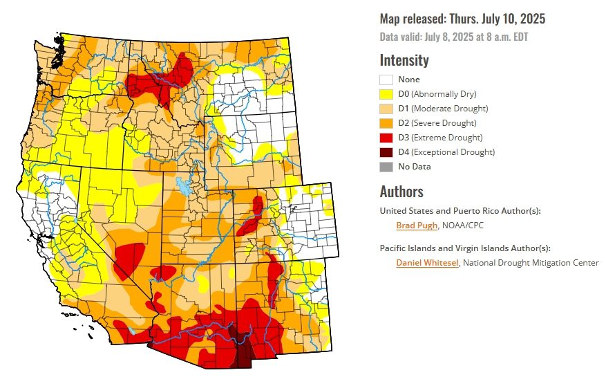
- Drought improves in parts of Arizona, Colorado, and New Mexico.
- Long-term drought persists in south-central Texas despite heavy rainfall.
- Conditions worsen in the Pacific Northwest and northern Idaho.
- The Desert Southwest sees slight drought reduction from Monsoon rains.
Saturday, July 12, 2025 — The United States Drought Monitor report released on Thursday reveals a shifting national drought landscape. While summer thunderstorms and widespread rainfall have improved drought conditions across the Great Plains and much of the South, the western United States is experiencing an intensification of dry conditions, particularly in the Pacific Northwest. Meanwhile, the Corn Belt remains largely drought-free, and Florida has seen drought mostly vanish from its peninsula after another round of intense storms.
Despite overall improvement, parts of Texas continue to grapple with long-term drought, now spanning multiple years. Even flash flooding across central and southern Texas this month has done little to reverse groundwater shortages. The Edwards Aquifer Authority’s long-term observation wells in Medina and Uvalde counties remain in extreme to exceptional drought status.
Meanwhile, temperatures between July 1 and 7 were 2 to 4 degrees Fahrenheit above normal in many parts of the country, including the Pacific Northwest and the Midwest, adding to evaporative demand and drought pressures in dry zones.
Arizona and New Mexico See Relief.
Improved conditions were reported for parts of New Mexico, including eastern regions that benefited from intense summer rainfall. Similarly, portions of Arizona experienced localized Monsoon showers that helped reduce the area classified as extreme drought. These improvements are welcome, although long-term dryness remains a concern in certain areas of the Southwest.
California: Early Promise Fades.
After a wet winter, the end of California’s wet season brought renewed concerns. Abnormal dryness has expanded across northern and central California, driven by low soil moisture and short-term precipitation shortfalls over the past 60 to 90 days. While no drastic changes occurred in the southern part of the state this week, forecasters are watching carefully for signs of worsening conditions amid hot weather and rising evaporative demand.
Colorado and Utah: Small Shifts.
In southwestern Colorado, improved conditions were noted based on precipitation and other drought indices, leading to slight upgrades in drought status. Utah, however, experienced mixed changes. Some areas saw further degradation in conditions due to high evaporative demand and low streamflow averages, underscoring the state’s vulnerability to both short-term and long-term shifts in moisture availability.
Nevada Holds Steady.
There were no significant changes in Nevada’s drought classification this week. However, with Monsoon activity expected to pause temporarily, forecasters warn that above-normal temperatures and dry conditions may dominate the short-term outlook in the state.
Wyoming: Stable for Now.
Eastern Wyoming benefited from earlier spring and summer rains, with no major changes to drought status reported this week. Most of the state remains in relatively stable condition thanks to above-average precipitation over the past three months.
The Weather Outlook.
Between July 10 and 14, a cold front is forecast to shift southeast across the central United States, providing the focus for thunderstorms. The most widespread, heavy precipitation (more than 1.5 inches) is expected across the Upper Mississippi Valley and Western Corn Belt, with locally heavy rainfall also possible as far south and west as the Southern Great Plains and eastern New Mexico. Daily convection with scattered storms is forecast across the Mid-Atlantic and Southeast, particularly east of the Appalachians.
In the West, the outlook presents a more complicated picture, particularly for the Colorado River Basin states:
-
Arizona, Southern Nevada, and Southern Utah are expected to enter a Monsoon lull, bringing drier weather and above-normal temperatures. This pause in seasonal rainfall may increase evaporative stress on soils and surface water systems already under pressure.
-
Eastern and Southern New Mexico could benefit from locally heavy rainfall, especially in areas influenced by lingering moisture from earlier Monsoon pulses. This region has the highest potential in the Basin for precipitation over the next few days.
-
Western Colorado and Central Utah may see limited Monsoon-related moisture, but overall precipitation probabilities are near normal to slightly above normal. However, streamflow recovery in drought-affected areas is still uncertain, and conditions could revert quickly without sustained rainfall.
-
Northern California, Nevada, and parts of western Utah face continuing dry and hot weather, driven by a persistent ridge over the Pacific Northwest. With soil moisture already declining and streamflows below average, this pattern could deepen existing drought classifications.
-
Wyoming remains divided: eastern areas may receive cooler temperatures and scattered storms, while western and southern portions, particularly those closer to Utah, will likely remain warm and dry.
Looking further ahead, the 6–10 day outlook (valid July 15–19) from the Climate Prediction Center continues to favor above-normal temperatures across much of the Pacific Northwest, Great Basin, southeastern California, and southern Arizona. Below-normal precipitation is most likely in the Pacific Northwest, while parts of eastern New Mexico and the Florida Panhandle show the strongest signals for above-average rainfall.
For the Colorado River Basin, this forecast underscores a tenuous balance: while short-term relief is possible in parts of the Lower Basin, long-term drought pressures, particularly in the Upper Basin states, remain a critical concern.