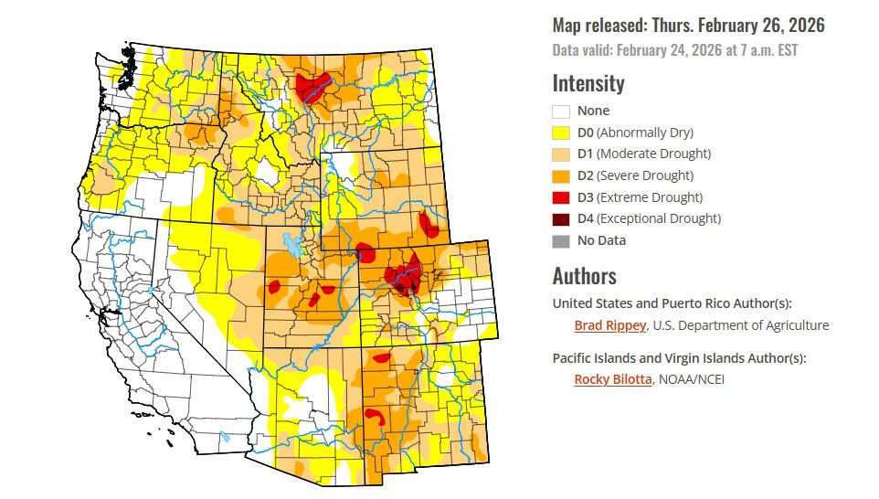
- Storms boosted snowpack in California’s Sierra Nevada but levels remain below normal for late February.
- Much of Arizona and New Mexico has snow-water levels below half of typical seasonal averages.
- Precipitation in the interior West has slowed drought expansion but provided limited long-term relief.
Saturday, February 28, 2026 — The latest report from the United States Drought Monitor shows a country experiencing sharply different weather patterns as February comes to a close.
Storm systems brought heavy snowfall to the Sierra Nevada in California, improving mountain snowpack that had been running below normal earlier in the winter. Some areas received several feet of snow, temporarily disrupting travel through mountain passes and contributing to a deadly avalanche near Lake Tahoe. In contrast, the central portion of the country experienced unusually warm temperatures and strong winds that fueled destructive wildfires in parts of the High Plains.
Farther east, several rounds of winter storms and rain improved drought conditions in parts of the Northeast and Southeast. Meanwhile, portions of the Midwest and southern Plains continued to experience worsening dryness.
While these shifting conditions affected different regions in different ways, the long-term water outlook in the western United States remains closely tied to snowfall in the mountains. That snowpack acts as a natural reservoir that slowly releases water into rivers and reservoirs throughout the year.
For the Colorado River Basin states, the situation remains uncertain.
Snowpack Gains in the West, But Still Below Normal.
Winter storms during February brought helpful snowfall to parts of the West. The Sierra Nevada snowpack gained roughly six inches of snow-water equivalent during the storms, according to the California Department of Water Resources.
Even with that increase, however, the snowpack remains below typical levels for late February. On average, the Sierra Nevada contained about 16 inches of snow-water equivalent—less than three-quarters of normal for this time of year.
Snow-water equivalent measures how much water is contained in the snowpack and is an important indicator of how much runoff may eventually reach rivers and reservoirs.
The storms helped prevent conditions from worsening in parts of the West that are already experiencing drought. However, much of the precipitation fell in areas that were not facing serious drought conditions.
Concerns Continue Across the Colorado River Basin.
Across the interior West—including much of the Colorado River Basin—conditions remain relatively dry.
Snow-water equivalent values are running well below average across large portions of Arizona and New Mexico. In many areas, snowpack levels are less than 50 percent of normal for this point in the winter season.
Snowpack is particularly important for the Colorado River Basin because the region relies heavily on mountain snowfall to replenish rivers, reservoirs, and groundwater supplies during the spring and summer.
Although isolated bursts of precipitation occurred in several western states, those events mainly slowed the spread of drought rather than reversing it.
Utah Snowfall Provides Limited Improvement.
One of the most notable snowfall events during the week occurred in Utah’s Wasatch Range, where the Alta ski area received more than 31 inches of snow within a 24-hour period between February 17 and February 18.
Despite that intense storm, snowfall totals across the region are still expected to end the month below average.
As a result, the additional snow has not significantly changed the broader drought picture across the interior West.
What the Latest Forecast Suggests.
Weather forecasts in late February indicated that the southwestern United States may remain relatively dry in the near term.
The National Weather Service outlook suggests warmer-than-normal temperatures across much of the country during early March. Meanwhile, precipitation patterns are expected to vary widely, with some regions receiving near-normal rainfall while others remain drier than average.
For the Colorado River Basin states—Arizona, California, Colorado, Nevada, New Mexico, Utah, and Wyoming—the remainder of the winter snow season will play a critical role in determining how much water ultimately flows into the river system later this year.
For now, the most recent drought data shows that while storms have brought short-term improvements in parts of the West, the broader challenge of below-average snowpack continues to shape water conditions across the Colorado River Basin.