- Heavy autumn rainfall brought widespread drought improvements across the Southwest and Great Basin.
- Short-term drought has ended across the region, but longer-term drought conditions remain.
- Parts of Arizona, Nevada, Utah, New Mexico and Colorado experienced improving conditions.
- More precipitation could reach the West by mid-November.
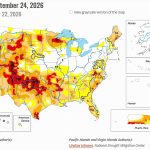
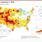
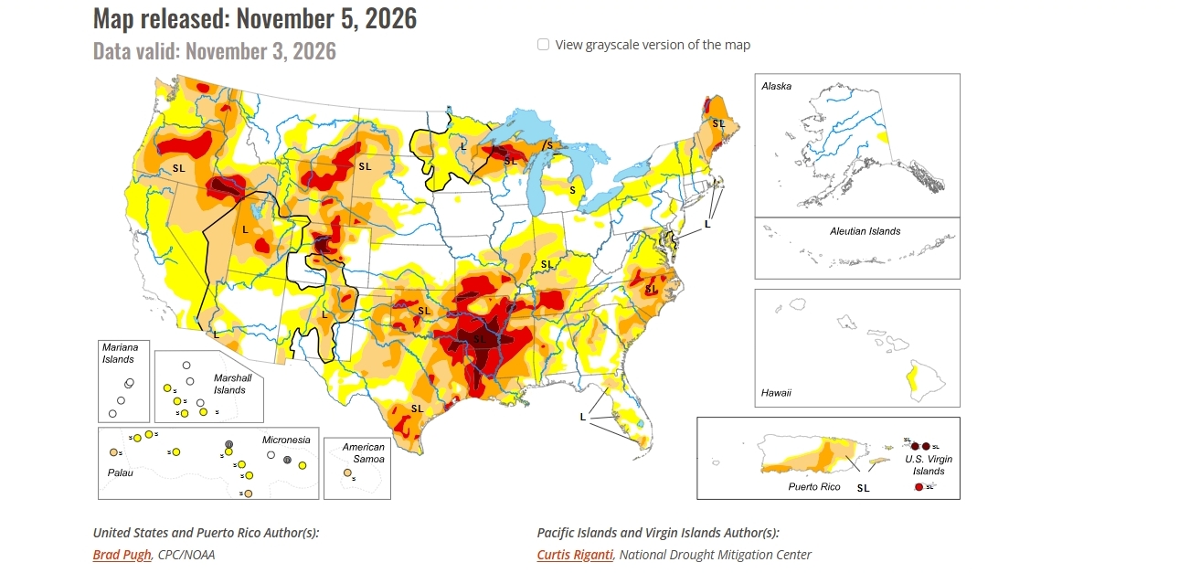
Saturday, November 7, 2026 — After months of unusually wet weather, drought conditions have improved across much of the southwestern United States. The latest U.S. Drought Monitor report , released November 5, 2026, shows widespread improvements across the Southwest, Great Basin and portions of the Great Plains.
The changes followed another round of heavy precipitation between October 27 and November 2. Many areas received more than an inch of rain during that period.
The improvements were especially noticeable across the seven Colorado River Basin states, where an unusually wet autumn has helped bring an end to short-term drought across much of the region.
However, the report makes an important distinction: Recent rainfall has ended short-term drought across the Southwest and Great Basin, but longer-term drought conditions remain in some areas.
Elsewhere in the country, drought conditions were mixed. Heavy precipitation helped improve conditions across parts of the Great Plains, Upper Mississippi Valley and Florida. Meanwhile, drought expanded or intensified in portions of the Mississippi Valley, Ohio Valley, Mid-Atlantic and New England.
Alaska and Hawaii remained free of drought, while conditions continued to improve in Puerto Rico.
Colorado River Basin States See Widespread Improvements.
The Southwest experienced another unusually wet period over Halloween weekend as a low-pressure system moved across southern California and the Desert Southwest.
According to the U.S. Drought Monitor, the system developed unusually far south for this time of year, bringing substantial precipitation to areas already experiencing a wetter-than-normal autumn.
During the preceding 60 days, precipitation across southern California, southern Nevada and most of Arizona and Utah reached 200 to 400 percent of normal, or even higher in some locations.
The report attributed part of the unusually wet autumn to an active eastern Pacific tropical cyclone season associated with El Niño conditions.
Another round of precipitation exceeding one inch supported widespread improvements in drought classifications from Arizona northward into Nevada, Utah and southeastern Idaho.
Across much of the Southwest and Great Basin, drought conditions improved by one category.
That means areas previously classified in a more severe drought category moved into a less severe category as rainfall and other indicators improved.
Despite these changes, the Drought Monitor emphasized that longer-term drought persists in portions of the region, with varying levels of severity.
New Mexico’s Short-Term Drought Ends.
New Mexico also benefited from the unusually wet autumn.
The November 5 report identified broad improvements across the state, with drought conditions generally improving by one category.
According to the Drought Monitor, short-term drought has ended in New Mexico.
The report also noted that additional improvements may be warranted in subsequent weeks as drought classifications are brought into closer agreement with longer-term measurements.
New Mexico’s improvements were discussed separately from those across the Southwest and Great Basin, but they reflect the same broader pattern of unusually wet fall weather affecting the region.
Western Colorado Benefits From Recent Precipitation.
Colorado experienced measurable drought improvements during the reporting period.
Widespread precipitation ranging from approximately half an inch to two inches, with higher amounts in some locations, supported one-category improvements across the western third of the state.
Other portions of the northern and central Great Plains also experienced improvements following recent precipitation.
The changes in western Colorado are particularly relevant to the Colorado River Basin because the western portion of the state includes areas within the river’s upper watershed.
The Drought Monitor did not provide reservoir storage figures or Colorado River runoff estimates in its weekly narrative.
California Shows a Mixed Drought Picture.
Southern California was among the areas that received unusually high precipitation during the preceding two months.
The Drought Monitor reported rainfall totals reaching 200 to 400 percent of normal, or more, across portions of southern California during the 60-day period.
The Halloween weekend storm also contributed to unusually wet conditions across the Desert Southwest.
Nevertheless, drought coverage and intensity remained generally unchanged across much of California during the latest reporting week.
The report therefore shows an important difference between recent rainfall and changes in drought classifications. Even when precipitation is well above normal, existing drought designations do not necessarily change immediately.
Rainfall Improves Short-Term Conditions, but Longer-Term Drought Remains.
The November 5 report clearly distinguishes between short-term and long-term drought.
Short-term drought reflects relatively recent shortages of precipitation and moisture. Longer-term drought considers conditions over extended periods.
Across the Southwest and Great Basin, recent rainfall has been sufficient to end short-term drought.
However, longer-term drought remains designated in portions of the region, even where recent rainfall measurements have been unusually high.
The Drought Monitor’s weekly assessment considered both recent precipitation and longer-term measurements when determining changes in drought severity.
This distinction explains why substantial autumn rainfall can produce widespread improvements without eliminating every drought designation.
What the Forecast Showed for Early November.
The outlook accompanying the November 5 Drought Monitor called for a generally drier period across most of the contiguous United States from November 5 through November 9.
For the Southwest, this represented a shift away from the unusually wet conditions that characterized much of the autumn.
However, the outlook also identified the possibility of another change in weather patterns by mid-November.
Forecasters said there was an increasing chance that an atmospheric river could affect the West Coast.
An atmospheric river is a long, narrow band of moisture in the atmosphere that can produce substantial precipitation when it reaches land.
For November 10 through November 14, the National Weather Service’s six- to ten-day outlook indicated:
- Greater than a 60 percent chance of above-normal precipitation across much of California and the Pacific Northwest.
- Greater than a 70 percent chance of above-normal precipitation in portions of northern California and southwestern Oregon.
- Above-normal precipitation favored across the Great Basin, Southwest and Rio Grande Valley.
The outlook also favored above-normal temperatures across nearly all of the contiguous United States, a pattern the Drought Monitor associated with strong El Niño conditions during autumn.
These were forecasts issued with the November 5 report, not observations of weather that had already occurred.
A Changing Drought Picture Across the Colorado River Basin.
The November 5 U.S. Drought Monitor documents substantial improvements across the Southwest following an unusually wet autumn.
Recent precipitation supported reductions in drought severity across Arizona, Nevada, Utah, New Mexico and western Colorado. Southern California also experienced exceptionally wet conditions during the preceding 60 days, although drought classifications remained largely unchanged across much of the state.
For the Colorado River Basin, the central finding is that short-term drought has ended across the Southwest and Great Basin, while longer-term drought conditions continue in portions of the region.
With additional precipitation favored in the mid-November outlook, subsequent Drought Monitor reports will provide updated assessments of how conditions are changing.