- The federal government released its first-ever unified outdoor recreation visitation report on June 25, 2026, as required by the Expanding Public Lands Outdoor Recreation Experiences Act.
- Outdoor recreation generates $1.2 trillion in economic output annually, supports 5 million jobs, and accounts for 2.3 percent of the nation’s gross domestic product.
- Forty pilot projects across the country will test new and innovative ways to count visitors, including the use of cell phone location data, game cameras, and social media.
- Several of those pilot projects fall within the seven Colorado River Basin states, covering national forests, national parks, Bureau of Land Management lands, and water-based recreation sites.
- The public has until July 27, 2026, to submit written comments on the proposed pilot protocols through the Bureau of Land Management’s online planning portal.
Friday, June 26, 2026 — For decades, the question seemed simple: how many people visit America’s public lands and waters each year? The honest answer, it turns out, was far more complicated than anyone let on.
Different federal agencies counted visitors differently. Some used traffic counters at entrance gates. Others relied on ranger estimates or campground registration records. Agencies managing lakes, reservoirs, rivers, and coastal waters had their own methods, which rarely matched what land-based agencies were doing. The result was a patchwork of data that was hard to compare and even harder to use for planning.
That changed on June 25, 2026, when the U.S. Department of the Interior announced the release of the Interagency Recreation Visitation Data Report , the first unified compilation of outdoor recreation estimates across all federal land and water management agencies. The report was required by the Expanding Public Lands Outdoor Recreation Experiences Act, a federal law signed in 2025 that has been working its way through implementation ever since.
“Outdoor recreation is a powerful economic engine and a defining part of the American way of life,” said Secretary of the Interior Doug Burgum. “With the first unified interagency visitation report, we now have clearer insight into how millions of people engage with their public lands and waters. This information will help federal agencies work together to improve visitor services, support rural and gateway communities and ensure that these opportunities remain accessible to all.”
The Numbers Behind the Trails — and the Water.
The stakes are significant. According to Interior Department figures, outdoor recreation supports $1.2 trillion in economic activity each year in the United States, sustains 5 million jobs, and represents 2.3 percent of the nation’s gross domestic product. That is not a niche industry. That is a major pillar of the American economy, one that flows directly through small towns, rural counties, and gateway communities near public lands and waters across the West.
Activities counted in the new report include biking, motorized and non-motorized boating, camping, fishing, hiking, hunting, interpretation and education programs, off-highway vehicle use, and sightseeing. Water-based activities such as boating and fishing feature prominently in that list, reflecting just how central rivers, reservoirs, and lakes are to the outdoor recreation economy. The report standardizes those 11 recreation categories across agencies for the first time, creating what federal officials describe as the most consistent and comparable interagency dataset ever assembled.
The agencies that contributed data include the National Park Service, Bureau of Land Management, U.S. Fish and Wildlife Service, Bureau of Reclamation, U.S. Forest Service, U.S. Army Corps of Engineers, and the National Oceanic and Atmospheric Administration’s Office of National Marine Sanctuaries. Both the Bureau of Reclamation, which manages major water infrastructure and reservoirs throughout the West, and the U.S. Army Corps of Engineers, which oversees hundreds of lakes and waterways nationwide, are full participants in this effort. Their inclusion is notable for western water users, since Bureau of Reclamation facilities alone draw millions of visitors to lakes and recreation areas built around federal water projects every year.
The report was developed by the Federal Interagency Council on Outdoor Recreation, a coordinating body that the Expanding Public Lands Outdoor Recreation Experiences Act formally established. The council includes representatives from all the major federal land and water management agencies and works with state, tribal, and local partners.
The Problem With the Old Way of Counting.
Ask a park ranger how many people hiked a popular trail last Saturday, and the answer is probably pretty good. Ask how many people floated a remote canyon river, fished a quiet cove on a federal reservoir, parked at a trailhead in the middle of nowhere, or scrambled up an unmarked ridge, and the answer gets murky fast.
That is the core problem federal managers face. Traditional counting methods, like vehicle counters at entrance stations or visitor surveys at campgrounds, simply do not reach people who are recreating in dispersed, low-traffic, or hard-to-reach places. Water-based recreation presents a particular challenge: someone launching a kayak from an unimproved boat ramp on a Bureau of Reclamation reservoir, or wading a backcountry stretch of a national forest river, is nearly invisible to existing monitoring systems. As more Americans venture off the beaten path and onto lesser-known waterways, that data gap grows.
Section 133 of the Expanding Public Lands Outdoor Recreation Experiences Act (EXPLORE) was written specifically to address this. It directs the Secretaries of Agriculture, Interior, Commerce, and the Army to establish pilot programs at no fewer than 10 land management units under each secretary’s control, testing new methods to capture what the old methods miss.
As the Federal Register notice published in connection with the pilot project effort describes it, these pilots are intended to “model recreation use patterns, including low-use recreation activities and dispersed recreation activities, that may not be effectively measured by existing general and opportunistic survey and monitoring protocols.”
In plain language: the government wants to count the hikers, paddlers, and anglers nobody is counting yet.
Forty Pilot Projects, Dozens of New Methods.
The Federal Interagency Council on Outdoor Recreation responded to that mandate by proposing 40 pilot projects spread across a range of landscapes and recreation settings throughout the country. Each project tests one or more of the newer tools now available to land and water managers.
Those tools include anonymized location data from mobile devices (essentially, the kind of movement data that smartphone apps collect), automated trail counters, manual counting by staff, handheld GPS units carried by visitors, written questionnaires, comment cards, game cameras set up in the field, community science contributions from the public, and analysis of social media posts.
None of these is entirely new on its own. What is new is the effort to test them systematically across a broad range of federal lands and waters, compare the results, and figure out which methods work best in which settings.
The U.S. Army Corps of Engineers is running 10 pilot projects of its own, all focused on water-based and water-adjacent recreation. Those projects use voluntary visitor comment surveys at sites including Hartwell Lake in Georgia, J. Percy Priest Lake in Tennessee, Raystown Lake in Pennsylvania, Lake Sakakawea in North Dakota, Lake Okeechobee in Florida, Libby Dam in Montana, the Cape Cod Canal in Massachusetts, the Washington Ship Canal in Washington state, the Bay Model in California, and the McClellan-Kerr Arkansas River Navigation System in Arkansas and Oklahoma. While none of those Army Corps projects fall within the Colorado River Basin states, they represent a significant portion of the overall pilot effort and serve as a model for how water-based recreation can be better measured nationwide.
Notably, while Bureau of Reclamation staff helped develop the overall pilot project list, the documents released on June 25, 2026 confirm that no Bureau of Reclamation recreation areas were included among the 40 proposed pilot locations. Given the enormous number of visitors who recreate at Bureau of Reclamation reservoirs throughout the West, that absence may draw attention during the public comment period.
“Interested parties are invited to submit written comments about the utility and adequacy of the proposed pilot protocols and the appropriateness of the proposed land management units for meeting the requirements of Section 133,” the Federal Register notice states.
That 30-day public comment window opened with the publication of the notice and runs through July 27, 2026.
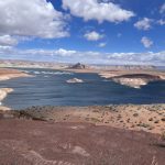
What This Means for the Colorado River Basin.
For residents and visitors in the seven Colorado River Basin states, several of the 40 proposed pilot projects land close to home. Here is a look at what is proposed for Arizona, California, Colorado, New Mexico, Nevada, Utah, and Wyoming.
Utah is home to one of the most closely watched pilot projects on the list. The National Park Service plans to use anonymized mobile device location data, automated on-site counters, and manual counting to study visitor travel patterns inside Bryce Canyon National Park. The goal is to better understand how visitors move through the park, not just how many arrive at the gate.
Colorado is included in two separate Forest Service pilot projects. The Arapaho and Roosevelt National Forests are the site of a study using visitor questionnaires, GPS tracking data, and trail, traffic, and parking counts to build a foundation for better transportation and visitor use management planning. Colorado also appears, along with Arizona, California, New Mexico, and several other western states, in a broader Forest Service project studying visitor patterns and economic benefits in national forests located in areas with high wildfire risk. That project uses social media data to develop visitation estimates.
Arizona and New Mexico both appear in that same high-wildfire-risk national forests study, which spans Arizona, California, Colorado, Idaho, Montana, New Mexico, Oregon, and Washington.
California has multiple pilot projects proposed within its borders. The National Oceanic and Atmospheric Administration plans to use mobile device location data to study visitor use at Manchester Beach and Salmon Creek Beach, both of which fall within the Greater Farallones National Marine Sanctuary along the Pacific Coast. Both sites are classified as low-use areas, making them good test cases for mobile data’s ability to detect visits that traditional methods would miss. The Army Corps of Engineers Bay Model project in the San Francisco Bay Area also falls within California and uses visitor comment surveys to measure water-based recreation use. The Forest Service’s Cleveland National Forest in Southern California is the site of a study combining visitor questionnaires, automated counters, and mobile device data to evaluate recreation capacity and use levels. California also appears in a multi-state Forest Service game camera and crowd-sourced data study.
Nevada and Wyoming do not appear as specific named locations in any of the 40 proposed pilot projects, based on the documents released as of June 25, 2026.
How to Weigh In.
Federal agencies and the U.S. Department of Agriculture Forest Service are accepting public comments on the proposed pilot projects through the Bureau of Land Management’s online planning portal through July 27, 2026. The comment opportunity covers both the specific methods proposed and the choice of locations where each pilot would be tested. Comments can be submitted here.