- Heavy precipitation brought drought relief to several Basin states.
- Parts of southern Colorado improved by two drought categories.
- Long-term moisture shortages persisted across much of the West.
- The October 29 forecast called for more precipitation in parts of Arizona and Colorado.
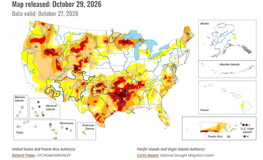
Saturday, October 31, 2026 — Drought conditions across the United States moved in different directions during the week covered by the October 29 U.S. Drought Monitor report . Much of the eastern half of the country received little or no rain, while storms brought widespread moisture to the West.
Warm, dry conditions worsened drought across parts of the lower Mississippi Valley and other southern areas. Farther west, repeated storms eased drought across portions of the seven Colorado River Basin states: Arizona, California, Colorado, Nevada, New Mexico, Utah and Wyoming.
Some of the greatest improvements occurred in the Four Corners region. Heavy precipitation also caused flooding in parts of Colorado and New Mexico. Despite the recent moisture, long-term shortages remained across much of the West, limiting how much drought could be removed.
Four Corners Sees Substantial Relief.
The latest storms continued a wet pattern across much of the Four Corners region, where Arizona, Colorado, New Mexico and Utah meet.
Some locations near the Colorado–New Mexico border received 4 to 8 inches of precipitation during the reporting period. Central and southern Colorado experienced excessive precipitation and areas of flooding.
Drought conditions improved by one category across much of southern Colorado and parts of northeastern Colorado. Portions of south-central and southwestern Colorado improved by two categories after receiving several inches of precipitation.
New Mexico also saw widespread improvement. Much of northern and eastern New Mexico received 2 to locally 5 inches, and the state reported localized flooding.
Improvements Extend Across the Southwest.
Central Arizona was among the western areas receiving 2 to locally 5 inches of precipitation. The continued wet pattern brought widespread drought improvement to central and northern Arizona.
A large part of Nevada also improved following several wet weeks. Additional improvements appeared in parts of the lower Colorado Valley and southern Utah.
Precipitation varied across California. Southeastern and southwestern California were among the areas reporting locally heavy amounts, while higher elevations in southern California received more than 2 inches.
Moisture moving north from the Four Corners brought moderate to locally heavy precipitation across much of Utah. Some higher-elevation locations in northern Utah and far western Wyoming received more than 2 inches. Western Wyoming also received moderate precipitation associated with a surge of tropical moisture.
The storms did not reach every area equally. Parts of the lower Colorado Valley, some lower-elevation locations and portions of the Desert Southwest received only light amounts, ranging up to a few tenths of an inch.
Recent Storms Have Not Erased Long-Term Shortages.
The report documented continued drought relief across much of the West, but complete drought removal remained limited.
Long-term moisture deficits continued to affect much of the region. Recent precipitation improved conditions but did not fully offset those shortages.
The contrast was especially clear in the Four Corners: repeated heavy precipitation brought substantial drought improvement, while some communities also experienced flooding.
What the October 29 Forecast Anticipated.
The October 29 outlook called for additional heavy precipitation through November 2.
Forecast totals ranged from 1.5 to locally near 4 inches across central Arizona and higher elevations of the central Rocky Mountains. That included parts of Colorado already affected by heavy precipitation during the reporting period.
Most higher elevations in the Rocky Mountains were forecast to receive roughly half an inch to locally near 2 inches. Daytime highs were expected to average 4 to 8 degrees Fahrenheit below normal across the central and western Four Corners, the Great Basin, and much of the Desert Southwest.
For November 3–7, the report favored above-normal precipitation across most of the contiguous United States. These outlooks were forecasts issued with the October 29 report, rather than measurements of precipitation received afterward.