
- The Bureau of Reclamation’s June 2026 report projects Lake Powell could fall to minimum power pool by spring 2027.
- Water flowing into Lake Powell in May 2026 was just 18% of the 30-year average, with June’s forecast dropping to a stark 7%.
- Emergency water releases from Flaming Gorge Reservoir are already underway to help prop up declining Lake Powell levels.
- The rules currently governing Colorado River operations expire at the end of 2026, adding uncertainty to an already stressed system.
- Total storage across the Colorado River system stood at 19.6 million acre-feet as of June 2026, a number that tells a sobering story.
Wednesday, June 17, 2026 – The Colorado River is sending a warning, and federal water managers are not ignoring it.
On June 15, 2026, the Bureau of Reclamation released its June 24-Month Study , a detailed forecast that projects where the river’s two largest reservoirs, Lake Powell in Utah and Lake Mead in Nevada and Arizona, are headed over the next two years. The news was not encouraging.
The report projects that Lake Powell, which sits behind Glen Canyon Dam and is a critical source of hydropower for millions of households across the Southwest, could fall to what is known as “minimum power pool” by spring 2027. Minimum power pool is the level at which the water drops so low that it can no longer spin the turbines inside the dam to generate electricity. That elevation sits at 3,500 feet above sea level.
As of the end of June 2026, Lake Powell’s water surface sat at approximately 3,523 feet. That sounds like a safe cushion, but the projections in the report show the lake dropping steadily each month. By January 2027, the report projects the elevation will fall to 3,498 feet, slipping below that critical 3,500-foot threshold. By March 2027, the lake could be as low as 3,488 feet.
What Is Happening to the Water?
The short answer is that the water is not coming. The Upper Colorado River Basin, the vast network of mountains and streams that feeds Lake Powell, is experiencing what the report describes as “historically dry conditions” in water year 2026.
Water year 2026 runs from October 2025 through September 2026. During that stretch, snowmelt and rain runoff flowing into Lake Powell have been far below normal. In May 2026, the observed inflow was 0.383 million acre-feet, which is just 18% of the 30-year average. For June 2026, forecasters projected only 0.170 million acre-feet, equal to 7% of average.
To put that in plain terms, the river is delivering roughly one-tenth of the water it would typically carry into the reservoir during the summer months.
Looking at the full water year, the forecast calls for a total inflow of 3.40 million acre-feet into Lake Powell, which is 35% of average. Historically, that kind of drought-level shortfall ranks among the worst the basin has recorded in modern times.
Emergency Measures Already in Place.
Federal water managers have not been standing still. Well before this latest report was released, the Department of the Interior took several steps to slow the decline of Lake Powell.
Reclamation reduced the annual release of water from Lake Powell from 7.48 million acre-feet down to 6.00 million acre-feet for water year 2026. Additional monthly releases between December 2025 and April 2026 were cut by a combined 0.598 million acre-feet.
Beyond cutting releases, Reclamation also activated a Drought Response Operations Plan, which calls for releasing up to 1.00 million acre-feet from Flaming Gorge Reservoir, located upstream on the Green River in Wyoming and Utah, into Lake Powell by April 2027. The June 2026 study reflects the full 1.00 million acre-feet release being executed.
Flaming Gorge is sometimes called the “battery” of the Upper Basin, a strategic reserve that can be drawn down in times of crisis to protect Lake Powell. That battery is now actively discharging.
Despite these measures, the report still projects Lake Powell falling below minimum power pool. The Bureau of Reclamation noted on June 15, 2026, that this outcome “is not a reflection of recent drought response actions, but rather a clear reminder that the Colorado River remains vulnerable and that updated operational tools are essential for long-term stability.”
The Expiring Rulebook.
Part of what makes this moment especially complicated is the legal framework that governs the entire Colorado River system. The rules that determine how much water each state gets, when releases are made, and what triggers cuts are currently set by a collection of agreements, most notably the 2007 Interim Guidelines, which expire at the end of 2026.
Because those guidelines have not yet been replaced, the June 24-Month Study was forced to model future operations using those same expiring rules. In the modeling, years beyond 2026 assume a continuation of the 2007 framework, even though everyone in the room knows those rules are on borrowed time.
Reclamation began the formal process of developing post-2026 operating guidelines back in June 2023. Those negotiations are ongoing. Until new rules are in place, the projections in reports like this one carry an asterisk, because nobody can say for certain how operations will be managed once the calendar flips to 2027.
Lake Mead Is Watching, Too.
While much of the attention in this report centers on Lake Powell, Lake Mead is also under pressure. Lake Mead, the nation’s largest reservoir, sits downstream behind Hoover Dam and stores water for delivery to cities and farms in Nevada, Arizona, and California.
As of June 2026, Lake Mead’s water surface stood at approximately 1,044 feet above sea level. The report projects that elevation declining to 1,036 feet by the end of December 2026, and further down to 1,015 feet by December 2027.
Operations at Lake Mead for calendar year 2026 are being conducted under a declared “Shortage Condition,” a formal designation that triggers mandatory water cuts for Arizona, Nevada, and Mexico under the Lower Basin Drought Contingency Plan. Major water users in the Lower Basin are already receiving less water than their full allocation. The Central Arizona Project, which carries Colorado River water to the Phoenix and Tucson metropolitan areas, is receiving 0.924 million acre-feet in 2026. The Metropolitan Water District of Southern California is receiving 0.941 million acre-feet, and Nevada is receiving 0.188 million acre-feet above Hoover Dam.
What Comes Next.
The June 24-Month Study is a planning tool, not a guarantee. The projections it contains will shift as actual conditions change. A wet fall or an unusual late-summer storm could slow the decline. Continued drought could accelerate it.
What the report makes clear is that the Colorado River system is under serious stress heading into 2027, and that the tools currently available to water managers are working within the limits of a rulebook that was written for a different era. With the post-2026 guidelines still being negotiated and reservoir levels trending downward, the months ahead will be closely watched by the seven states, two countries, and tens of millions of people who depend on the Colorado River for their water supply.
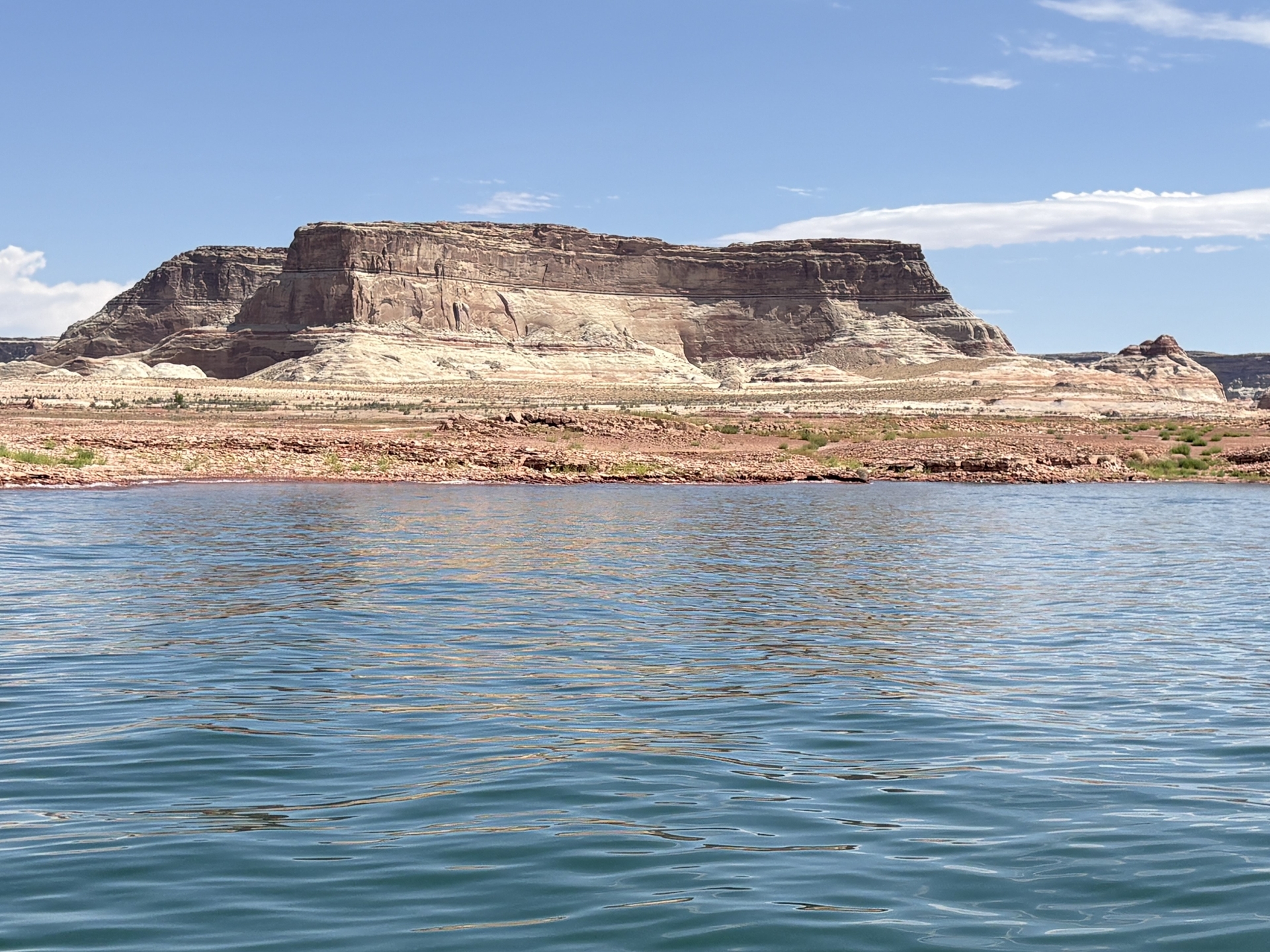
Pictured: From the Bureau of Reclamation’s X.com post, an image taken from Lake Powell showing the low water levels against the canyon.


Thanks for your comment! I think this the drought / climate situation is worrying water managers across the country and the world, for that matter.