- Scientists warn the Colorado River system could “crash” if next year brings another dry winter.
- Even a very wet year would give the region only about two years of breathing room before the crisis returns.
- The three biggest reservoirs combined hold just 6.22 million acre-feet of water that can actually be used.
- Agriculture accounts for more than half of all water consumption in the basin, making it a central focus of any solution.
- A system crash would not immediately shut off city taps, but it would devastate farms across the Southwest.
Thursday, June 11, 2026 — Picture a savings account that keeps getting overdrawn. Every few years, a big deposit comes in and things look a little better. But the withdrawals never stop, and the balance just keeps creeping lower. That, in plain terms, is what is happening to the Colorado River right now.
A team of five prominent water policy and science experts released a sobering new paper on June 1, 2026, updating analysis they first published in September 2025. Their conclusion is both simple and alarming: the Colorado River Basin is spending far more water than nature is putting back in, and the cushion in the system’s two biggest reservoirs is nearly gone.
Who Wrote This and Why It Matters.
The paper’s authors are not activists. They are former federal water commissioners, reservoir scientists, retired water district managers, and law professors from the University of Colorado, Utah State University, Arizona State University, and the University of New Mexico. They have spent careers working inside the very systems they are now warning about.
Their message, directed at water managers, state and federal officials, and the general public, is straightforward: what has been done so far to save water is not enough.
Where the Water Stands Right Now.
The Colorado River serves about 40 million people across seven states and parts of Mexico. Its water fills fields of lettuce, cotton, and alfalfa. It flows through kitchen taps in Las Vegas, Phoenix, Los Angeles, and Denver. And it is stored, between rainstorms and snowmelt years, in a chain of reservoirs that act as the region’s water bank.
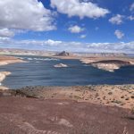
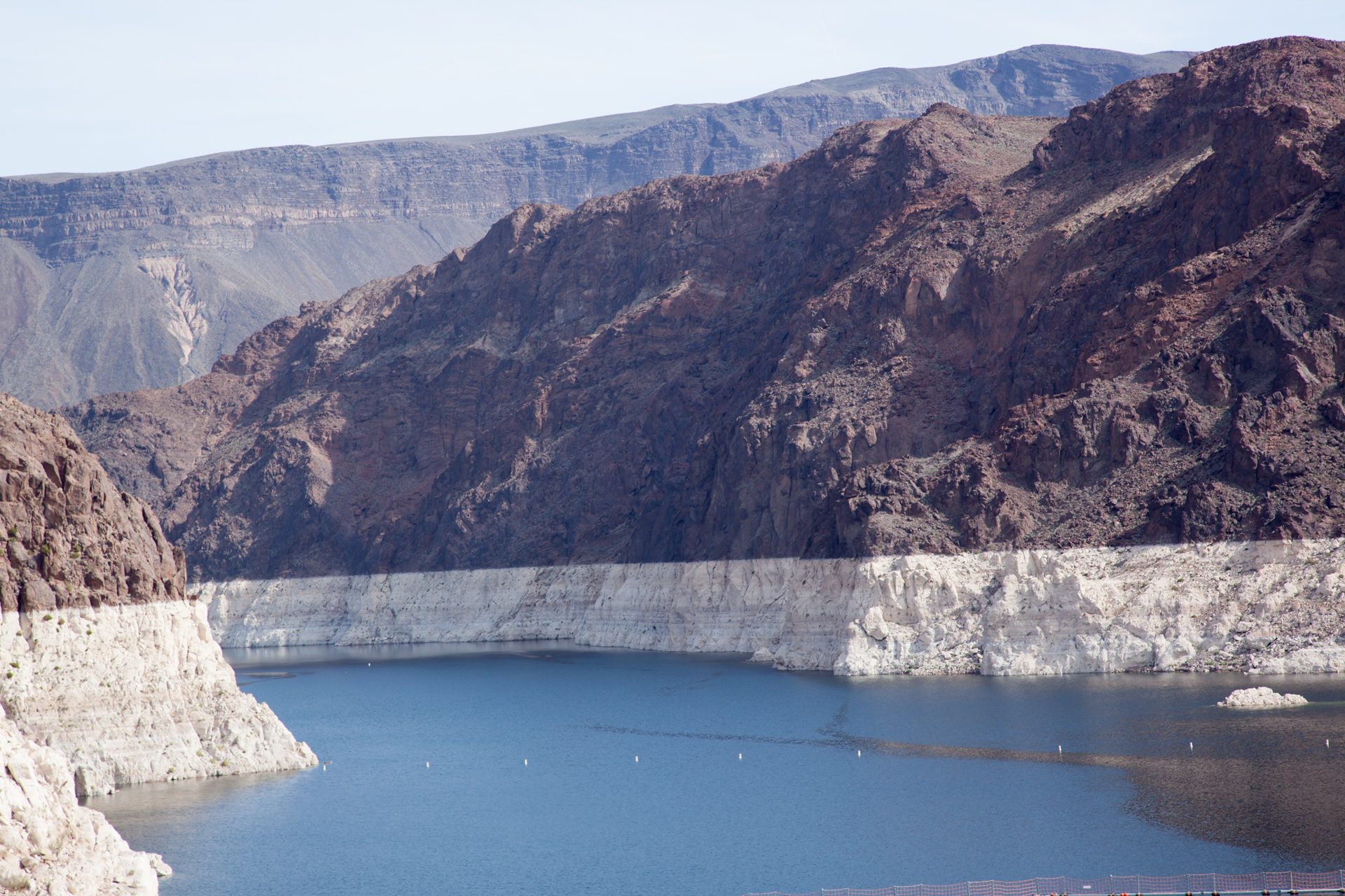
The two biggest vaults in that bank are Lake Powell, tucked into the canyon country of southern Utah and northern Arizona, and Lake Mead, the massive reservoir behind Hoover Dam on the Nevada-Arizona border.
As of the projections released by the Bureau of Reclamation in its May 2026 planning report, those two reservoirs, along with Flaming Gorge Reservoir in Wyoming and Utah, hold a combined 14.11 million acre-feet of water in what engineers call “active storage.” That sounds like a lot. But the authors focus on a much smaller number: the water that can actually be used without risking damage to the dams themselves.
That usable cushion, what the authors call “realistically accessible storage,” sits at just 6.22 million acre-feet across all three reservoirs. To put that in perspective, the Basin uses roughly 11 to 13 million acre-feet every single year.
The Ratchet That Only Turns One Way.
The authors use the phrase “ratchet effect” to describe a pattern that has played out across this entire century. Dry years drain the reservoirs hard. Occasional wet years bring some relief. But the relief never fully undoes the damage, and the next dry stretch pulls the system lower than it was before.
This pattern began dramatically in the early 2000s. Lake Powell and Lake Mead lost 52 percent of their combined usable capacity in just the first five years of this century, between fall 1999 and January 2005. They were still at that same depleted level going into 2020. Then conditions got even worse between 2020 and 2022. By March 2023, the two reservoirs held only 27 percent of what they had contained in fall 1999.
Water Year 2026 is now shaping up to be one of the lowest runoff years ever recorded, the authors note. The snowpack that feeds the river this past winter came in far below predictions, leaving the system in a position few water planners anticipated this soon.
Two Possible Futures for Next Year.
The authors ran two scenarios for Water Year 2027, which runs from October 1, 2026, through September 30, 2027.
If next year is dry — similar to Water Year 2025, which was the fifth driest of this century — the math is dire. Even if every water user across the entire Basin cuts back to the lowest consumption levels on record, the river would still come up roughly 2.59 million acre-feet short of what is being used. That gap would have to come out of the reservoirs. When the year ended, the three major reservoirs together would hold only 3.63 million acre-feet of usable water.
At that point, Lake Powell and possibly Lake Mead would likely be operating as what engineers call “run-of-the-river” facilities — meaning the dams would no longer be storing water at all, simply passing through whatever flows in. That is what the authors mean when they say the system could “crash.”
If next year is very wet — similar to Water Year 2023, the third wettest year of this century — the reservoirs would recover and hold about 11.05 million acre-feet of usable water by the end of the year. That sounds like genuine relief. But the authors caution that this amount would sustain the region for only about two years at current consumption levels before the system would be back in crisis.
“Even a relatively wet year provides merely a short reprieve from crisis if the pattern seen in the 21st century of multiple, consecutive dry years following individual wet years continues,” the authors wrote.
The Difference Between a Crash and Your Tap Going Dry.
One important distinction the authors make is worth understanding clearly. A system crash would not mean that city water systems across the Southwest would immediately run out of water. Many cities have spent years and significant money building what water managers call “diverse portfolios” — backup sources that include groundwater wells, local rivers, and recycled water.
What a crash would devastate, far more immediately and directly, is agriculture.
Farms in the Southwest operate under a complex system of water rights that has been in place for more than a century. When reservoirs drop to run-of-the-river conditions, the reliable, year-round supply that makes large-scale irrigation possible simply disappears. Fields go unplanted. Crops fail. Rural communities that depend on farming shrink or disappear.
Where the Water Is Going.
The paper points to a number that frames the entire problem. Agriculture accounts for more than half of all consumptive water use in the Colorado River Basin. Municipal, commercial, and industrial uses combined account for only about 18 percent.
This does not mean cities are off the hook. But it does mean that any serious plan to close the gap between what the river provides and what the Basin uses must focus heavily on how water is applied to crops.
The authors do not prescribe specific policies. They do urge that “strategies for substantially reducing agricultural water use should be a major focus of the discussion.”
Why the Government’s Own Forecast May Be Too Rosy.
The authors raise a pointed concern about the Bureau of Reclamation’s standard planning tool, the 24-Month Study published each month. That study’s most pessimistic scenario for the coming year, the authors argue, is still more optimistic than actual recent experience warrants.
The reason is technical but important. The government’s river forecast center uses a 30-year reference period stretching back to 1991 to estimate future flows. That period includes years that were wetter than the past decade has been. In effect, the baseline used to forecast “a bad year” reflects conditions that no longer represent how dry the river has actually been running.
Water Year 2025 was the fifth driest of this century and the third driest of the past ten years. Yet the government’s minimum probable forecast for next year would represent only the sixth driest of the past decade, meaning the official “worst case” is actually wetter than the recent median. The authors argue this approach is not adequate for prudent planning.
The Assigned Water Problem.
The paper also flags an issue that could turn a crisis into a legal and political brawl. As of the end of 2025, approximately 3.60 million acre-feet of water had been formally assigned to specific users in Lake Mead under a program that allowed water users to store conserved water in the reservoir for future use.
If Lake Mead drops low enough that there is not sufficient water to honor both those assignments and regular water deliveries, conflicts over who gets what could intensify sharply. The authors have addressed this issue in a separate paper on the topic of assigned water after the current operating guidelines expire.
What the Authors Are Calling For.
The language at the end of the paper is unusually direct for an academic policy document.
“Basin water users must focus on solutions to this fundamental, wet-water math problem, rather than legal arguments over paper water,” the authors wrote. They call for “significant reductions in consumptive uses across the entire Basin, beyond what has been accomplished to date.”
They acknowledge that political pressures will be intense. Every state, every water district, every farming community will fight to protect its own supply. But the authors argue that the consequences of allowing the system to crash would be “devastating for those same water users.”
The paper closes with a sentence that leaves little room for ambiguity: “This cannot be allowed to happen.”
What Comes Next.
The Bureau of Reclamation is expected to issue a formal Record of Decision governing how Lake Powell and Lake Mead will be operated after the current 2007 guidelines expire. That decision is anticipated later in 2026. The Lower Basin states — Arizona, California, and Nevada — submitted their own operational proposal in early May 2026, and the Department of the Interior issued a preliminary response on May 28, 2026.
Whether those negotiations will produce cuts deep enough to change the trajectory the authors describe remains to be seen. What the math makes clear, the authors say, is that the window for making those cuts while there is still meaningful water in the bank is closing fast.
The full paper, “Update: Colorado River Basin Storage Continues Slide Toward System Crash,” was released June 1, 2026, and was authored by Anne Castle of the University of Colorado Law School, Jack Schmidt of Utah State University, Eric Kuhn of the Colorado River Water Conservation District, Kathryn Sorensen of Arizona State University, and Katherine Tara of the University of New Mexico.