
- Lake Powell held less than 24 percent of its total capacity as of July 9, 2026, with seasonal inflows running at just 15 percent of the historical average.
- Six major wildfires burned hundreds of thousands of acres across the basin’s core states during the week ending July 11, 2026.
- Interstate negotiations over post-2026 Colorado River water rules remained unresolved as a federal environmental decision deadline approached.
- Local water managers across Arizona, California, Nevada, Colorado, and New Mexico forged new cooperative agreements even as state-level talks stalled.
- More than 120 rafters and campers were evacuated from the Colorado River in Mesa County, Colorado, as wildfire threatened the river corridor.
Saturday, July 11, 2026 — Here’s a roundup of water news from across the Colorado River Basin states, compiled from reports by other news organizations. Sources are linked at the end of this article.
Running Out of Time and Water.
The Colorado River Basin is experiencing a punishing season. Reservoirs that supply drinking water, irrigation, and electricity to roughly 40 million people are draining fast. Wildfires are chewing through forests and grasslands at a rate well above normal. And the political clock for replacing the legal agreements governing how every drop of that river is used is ticking down to its final months.
None of these problems is separate from the others. Together, they are squeezing the Basin from every direction at once.
The Legal Deadline Nobody Can Ignore.
Every agreement that governs how the seven Colorado River Basin states share the river, handle shortages, and cooperate with Mexico expires on December 31, 2026. The Bureau of Reclamation, the federal agency that manages the river’s two largest reservoirs, has committed to issuing a final environmental decision before October 1, 2026, with or without a deal from the states.
That decision will shape river management for potentially decades.
The seven states have not agreed on anything. The Upper Basin states, which include Colorado, Wyoming, Utah, and New Mexico, and the Lower Basin states of Arizona, California, and Nevada are far apart on the most basic questions. Who takes the biggest cuts? Can the Upper Basin’s reservoirs keep being drained to help the Lower Basin? Does any new plan need Congress to sign off before it can take effect?
A Congressional Research Service report updated May 19, 2026 laid out the math plainly. The river has been legally promised to more users than it can actually supply for decades. From 2000 through 2024, the river averaged about 12.4 million acre-feet of actual flow per year. On paper, states and countries hold rights to roughly 16.4 million acre-feet. To stabilize the system, everyone combined would need to use 13 to 20 percent less water than they currently do. None of the federal government’s proposed action alternatives fully closes that gap under all modeled conditions. Three of the four alternatives would require new congressional approval to put into effect.
An acre-foot is the amount of water that would cover one acre of land one foot deep, or about 326,000 gallons. A family of four typically uses about one acre-foot per year.
New Mexico Brings in a Fresh Voice.
At an Upper Colorado River Commission meeting in Denver on June 23, 2026, New Mexico introduced a change at the negotiating table. Tanya Trujillo, a veteran of the Biden administration’s Interior Department water and science office, replaced Estevan López as the state’s chief negotiator. Trujillo described New Mexico’s posture as one of fresh collaboration.
But she stepped into a room with little flexibility. Colorado’s chief negotiator Becky Mitchell put the situation directly: “A solution is much easier to find when there’s flexibility of storage. We do not have that now.” Wyoming’s Brandon Gebhart warned that using Upper Basin storage reservoirs as a relief valve for the Lower Basin is “a finite tool, not a solution.”
Inside Climate News reported on the June 23 meeting, noting that the federal government intended to release its final environmental impact statement in mid-July absent a seven-state consensus, a deadline that fell within the week ending July 11, 2026.
Small Deals, Big Meaning
While the state capitals argued, water managers on the ground were quietly doing business. Circle of Blue reported July 7, 2026, that six water suppliers in Arizona, California, and Nevada signed a memorandum of understanding with the Bureau of Reclamation in June to facilitate exchanges of desalinated and recycled water for Colorado River entitlements. In practical terms, that means bringing new water into the system to replace some of what the river can no longer reliably provide.
Phoenix and Tucson announced a joint emergency reserve mechanism that their managers described internally as “an easy button” for moving water to cities facing shortages. On Colorado’s Western Slope, irrigation districts voluntarily drew less than their full legal entitlements to share supply with downstream towns. In New Mexico, Santa Fe’s water utility entered early conversations with neighboring pueblos about shared underground storage infrastructure and emergency protocols in the event a wildfire contaminated a watershed.
These local arrangements do not solve the river’s structural deficit, analysts noted, but they represent a practical adaptation happening outside the spotlight of high-stakes interstate talks.
Lake Powell: 175 Feet Below Full.
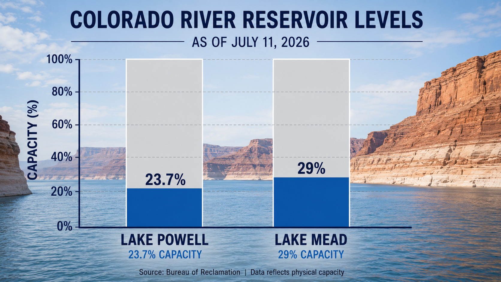
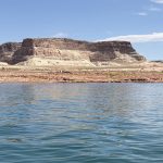
Lake Powell, the giant reservoir straddling the Utah-Arizona border, sat at approximately 3,524.57 feet above sea level as of July 9-10, 2026, according to real-time data from the Lake Powell Water Database. That is about 175 feet below the elevation at which the reservoir is considered full, and roughly 35 feet lower than the same date in 2025. The reservoir held just under 23.7 percent of its total capacity.
Water was coming in far slower than it was going out. Daily inflows averaged between 3,900 and 4,600 cubic feet per second during the first week of July, while outflows through Glen Canyon Dam ran near 7,900 cubic feet per second. At that pace, the lake was dropping between 0.12 and 0.16 feet per day.
The cause traces directly to snowpack. The Bureau of Reclamation’s June 29, 2026, weekly hydrologic update reported that April-through-July inflows into Powell were forecast at approximately 950,000 acre-feet, or just 15 percent of the historical average for that period. Year-to-date inflows were running at roughly 41 percent of the long-term average.
Powell currently sits about 35 feet above the minimum power pool level of 3,490 feet. Below that elevation, Glen Canyon Dam can no longer generate electricity reliably. That margin is shrinking daily.
Reclamation has taken two significant steps to slow the decline. The agency is pulling approximately one million acre-feet from Flaming Gorge Reservoir, which sits on the Utah-Wyoming border, and routing that water toward Powell. At the same time, Reclamation cut the annual release from Glen Canyon Dam into Lake Mead by 1.48 million acre-feet through September 2026. The first move helps Powell. The second directly accelerates Mead’s fall.
Of the 17 boat ramps at Lake Powell, only two remained usable as of early July: the Bullfrog North Ramp and the Stateline Auxiliary Ramp. The main Wahweap launch, Antelope Point, and Halls Crossing were all out of reach at current water levels.
Lake Mead: Approaching Record Territory.
Lake Mead, the nation’s largest reservoir by capacity and the primary storage pool for the Lower Basin, stood at 1,047.14 feet above sea level as of June 29, 2026, holding approximately 29 percent of its capacity, according to the Bureau of Reclamation’s weekly update.
The Bureau’s May 2026 24-month study, a probabilistic modeling tool rather than a guaranteed forecast, projected that Mead could fall to around 1,036 feet in 2026, edging slightly below the 2022 record low of approximately 1,040 feet. Under the probable minimum inflow scenario, the same study projected Mead could reach around 1,011 feet by May 2028.
Hoover Dam, which sits at the downstream end of Mead and generates electricity for Nevada, Arizona, and California, requires a minimum lake elevation of 950 feet to operate its turbines. That threshold is still well below current levels, but the reduced releases from Powell will cut Hoover’s generating capacity by up to 40 percent, according to KTNV Las Vegas, which reported on the projections in recent months.
Note on data: The most current verified figures for both reservoirs point to early July 2026. Conditions as of July 11, 2026 may differ modestly. Reservoir projection scenarios represent modeled outcomes based on inflow assumptions, not guaranteed forecasts.

Fire Across the Basin.
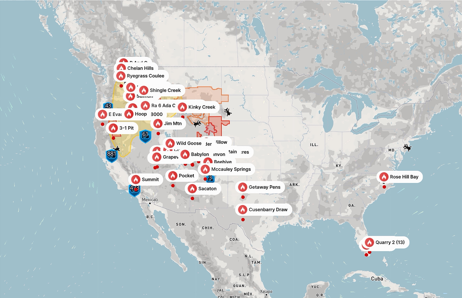
The National Interagency Fire Center raised the national wildfire preparedness level to Level 4, out of a maximum of 5, for the week beginning July 6, 2026. That designation signals that fire activity is significant enough to strain resources across multiple regions, and it limits how quickly personnel and equipment can shift to any single incident. By early July, approximately 3.14 million acres had burned nationwide since the start of the year, representing 157 percent of the 10-year average across roughly 35,900 fires.
Six large fires were burning within the Colorado River Basin’s core states last week.
Utah: Historic Fires in Canyon Country.
The Cottonwood Fire, burning near Beaver in southwestern Utah, had grown to approximately 94,400 acres with 23 percent containment, making it the sixth-largest wildfire in Utah history. More than 150 structures were lost.
The Babylon Fire, burning near Bears Ears National Monument in southeastern Utah, reached approximately 87,600 acres with zero percent containment. Fire officials described it as Utah’s first megafire in eight years. The Needles District of Canyonlands National Park was closed to visitors.
Colorado: Water Infrastructure in the Crosshairs.
In Pueblo County, the Aspen Acres Fire near the town of Beulah had burned approximately 89,100 acres with 13 percent containment, ranking as Colorado’s seventh-largest fire on record. Evacuation orders remained active for Beulah, Colorado City, Rye, San Isabel, and Wetmore.
The Ferris Fire in western Colorado reached approximately 41,300 acres with just 7 percent containment. It threatened the town of Dolores, Lone Mesa State Park, and critically, the McPhee Dam corridor. McPhee Reservoir and its associated infrastructure serve agricultural users and municipalities in the Dolores Project area. A wildfire damaging water delivery infrastructure in an already water-stressed region would compound shortages beyond what the drought alone is causing.
The Gold Mountain Fire, ignited by a downed power line near Ouray and Ridgway, grew to approximately 26,400 acres with 0% containment. Evacuation orders remained active in the Ridgway area.
The Knowles Fire in Mesa County prompted the emergency evacuation of more than 120 rafters and campers from the Loma and Westwater sections of the Colorado River. Drought-reduced water levels made jet-boat access impossible, and rescuers coordinated high-rail vehicles along Union Pacific railroad tracks to reach stranded visitors. The last group was extracted shortly before 2 a.m.
Arizona: Sedona Region Under Threat.
The Pocket Fire, burning north of Sedona, had reached approximately 25,200 acres with 38 percent containment. Temporary flight restrictions remained in place around Flagstaff.
When Fire Meets Water.
Fires and water shortages are not happening alongside each other by coincidence. They share the same root cause.
Historically, a thin snowpack means rivers running at a fraction of normal volume, soils holding almost no moisture, and vegetation drying out weeks earlier in the year than usual. That combination creates ideal conditions for large, fast-moving fires.
In turn, fires directly threaten the water systems people depend on. The Ferris Fire near McPhee Dam is one vivid example. Santa Fe’s early conversations with neighboring pueblos about wildfire contingency protocols for watershed contamination are another. A single large fire burning through a city’s watershed can force water treatment plants offline and leave communities scrambling for an alternative supply.
The relationship runs the other direction as well. Lower reservoir levels and reduced streamflows mean there is less water available to fight fires, to cool fire-suppression aircraft, and to support the communities that serve as base camps for firefighting crews.
NASA’s Earthdata program published a satellite image July 2, 2026, captured by the Visible Infrared Imaging Radiometer Suite instrument aboard the Suomi National Polar-orbiting Partnership satellite on July 1, 2026. The image showed simultaneous fire activity across Arizona, Utah, Colorado, and New Mexico, with aerosol overlays confirming smoke plumes extending well beyond fire perimeters.
Source Roundup.
Inside Climate News
“As Colorado River States Struggle to Reach Agreement, New Mexico Brings on a Fresh Voice”
June 23, 2026 | Basin-wide / New Mexico
Reports on the Upper Colorado River Commission meeting in Denver; New Mexico appoints Tanya Trujillo as new negotiator; states remain divided; federal final environmental impact statement targeted for mid-July 2026.
https://insideclimatenews.org/news/23062026/tanya-trujillo-upper-colorado-river-commission/
Circle of Blue
“Forget Western Water War: Local Managers Choose Partnership”
July 7, 2026 | Arizona, California, Nevada, Colorado, New Mexico
Six-agency desalination and recycled water agreement with the Bureau of Reclamation; Phoenix-Tucson emergency reserve mechanism; Western Slope voluntary conservation; Santa Fe-pueblo infrastructure talks.
https://www.circleofblue.org/2026/solutions/forget-western-water-war-local-managers-choose-partnership/
Congressional Research Service
“Management of the Colorado River: Water Allocations, Drought, and the Federal Role” (Report R45546)
May 19, 2026 | Basin-wide
Comprehensive analysis of post-2026 policy landscape, shortage figures, tribal rights, environmental impact statement alternatives, and congressional options.
https://www.congress.gov/crs-product/R45546
Bureau of Reclamation
“Lower Colorado Weekly Hydrologic Update: June 29, 2026”
June 29, 2026 | Basin-wide
Lake Powell at 3,527.58 feet, 24 percent capacity; Lake Mead at 1,047.14 feet, 29 percent capacity; April-through-July inflow forecast at 950,000 acre-feet, 15 percent of historical average.
https://www.usbr.gov/lc/region/g4000/weekly.pdf
Lake Powell Water Database
“Real-Time Lake Powell Level Data”
July 9, 2026 | Utah / Arizona
Powell at 3,524.57 feet as of July 9, 2026; 23.71 percent capacity; 175 feet below full pool; down approximately 35 feet from one year earlier; most boat ramps unusable.
https://lakepowell.water-data.com/
KTNV Las Vegas
“Lake Mead Water Levels Could Hit Record Lows Again This Summer”
2026 | Nevada / Arizona
Bureau of Reclamation projects Mead dropping to approximately 1,040 feet in July 2026, matching the 2022 record; potential decline to 1,011 feet by May 2028; reduced Powell releases projected to cut Hoover Dam hydropower output by up to 40 percent.
https://www.ktnv.com/news/lake-mead-water-levels-could-hit-record-lows-again-this-summer
ABC News
“Water Supplies Along Colorado River Basin in Peril, Experts Say”
May 20, 2026 | Basin-wide
Bureau of Reclamation 24-month study projects record-low Mead at 1,036 feet; April-through-July Powell inflow at 13 percent of average; expert context on hydroclimate variability.
https://abcnews.com/US/water-supplies-colorado-river-basin-peril-experts/story?id=133107551
USA TODAY
“Colorado River Rafters Evacuated, 3 Firefighters Killed Amid Wildfires”
June 29, 2026 (updated July 1, 2026) | Colorado
More than 120 river rafters evacuated from the Loma and Westwater sections of the Colorado River in Mesa County; Knowles Fire forces emergency river rescue operation.
https://www.usatoday.com/story/news/nation/2026/06/29/western-wildfires-colorado-river-rafters-evacuated/90736672007/
Property Guardian
“Weekly United States Wildfire Outlook: Week of July 6, 2026”
July 6, 2026 | Basin-wide
National Interagency Fire Center Preparedness Level 4; 3.14 million acres burned year-to-date at 157 percent of average; detailed status of six major basin fires; snowpack and climate drivers.
https://www.propertyguardian.com/news/active-wildfires-july-6/
Western Water
“Wildfires and Drought Grip the Colorado River Basin”
July 4, 2026 | Basin-wide
Cottonwood Fire at 94,000 acres near Beaver, Utah; soil moisture data; near-term weather outlook.
https://www.western-water.com/2026/07/04/wildfires-and-drought-grip-the-colorado-river-basin/
Western Water
“Drought Monitor Report: Heat and Fire Grip Colorado River Basin”
June 27, 2026 | Basin-wide
Extreme to exceptional drought across the Four Corners region; Arizona rangeland 75 percent rated very poor to poor; Iron Fire near Eureka, Utah at more than 37,000 acres.
https://www.western-water.com/2026/06/27/drought-monitor-report-heat-and-fire-grip-colorado-river-basin/
NASA Earthdata / Worldview
“Wildfires in Arizona, Utah, Colorado, and New Mexico”
July 2, 2026 | Arizona, Utah, Colorado, New Mexico
Visible Infrared Imaging Radiometer Suite satellite imagery from July 1, 2026 documents simultaneous active fire signatures across four states; Babylon, Ferris, Gold Mountain, Aspen Acres, and Pocket fires documented with aerosol overlays.
https://www.earthdata.nasa.gov/news/worldview-image-archive/wildfires-arizona-utah-colorado-new-mexico
Data note: Lake Powell and Lake Mead figures cited in this article draw on Bureau of Reclamation and third-party data dashboards updated through July 9-10, 2026. The Bureau’s weekly hydrologic update is dated June 29, 2026; conditions through July 11, 2026 may differ. Wildfire acreage figures from the July 6, 2026 Property Guardian outlook reflect conditions at time of reporting and changed rapidly through the week. Reservoir projection scenarios from the Bureau’s 24-month study represent modeled outcomes under specific inflow assumptions, not guaranteed forecasts. Where reporting from different outlets cited differing acreage totals for the same fire on similar dates, figures reflect likely differences in reporting time as fires evolved rapidly.


 wpDiscuz