
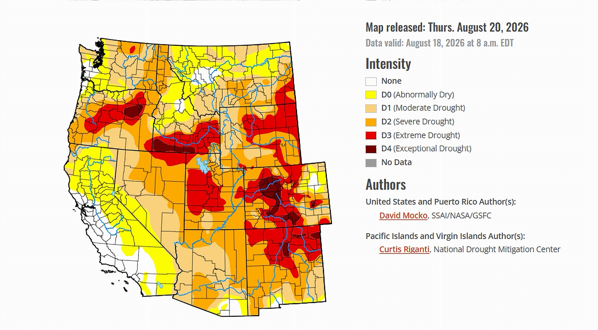
- Summer monsoon storms delivered small pockets of relief to southern Arizona and southern Utah.
- Eastern Colorado and eastern Wyoming improved after a run of welcome rain.
- Extreme drought still blankets much of Colorado, Wyoming, and Utah, with exceptional drought lingering in parts of Colorado.
- California, Nevada, and eastern New Mexico stayed dry, and conditions there slipped backward.
Saturday, August 22, 2026 — The latest U.S. Drought Monitor , released August 20, 2026, describes a country split between the soaked and the parched. Storm after storm rolled through the nation’s midsection, while a stubborn dome of high pressure baked much of the South.
A Country Divided by Rain.
The heaviest rain of the week fell in a broad band that ran from Nebraska east through Iowa, Illinois, Indiana, Ohio, and into West Virginia. Central Illinois and Indiana picked up more than five inches. Parts of eastern Indiana were buried under more than a foot of rain in a single week.
Farther south, the story flipped. A ridge of high pressure parked over the southern states choked off rainfall across the southern Great Plains and the lower Mississippi valley. Temperatures ran well above normal there, and the hottest readings settled over Oklahoma. The report notes flash drought taking hold across Texas, Louisiana, Arkansas, and Oklahoma, where ponds and creeks dried up and crops slid into poor condition. The most severe categories on the map, extreme drought (D3) and exceptional drought (D4), still covered western Oklahoma, the Texas Panhandle, and southeastern Arkansas.
In the Southwest, the summer monsoon kept working. Scattered storms dropped between half an inch and an inch and a half across the region.
The Colorado River Basin: A Week of Give and Take.
For the seven states that share the Colorado River, the week landed somewhere in the middle. Some corners caught a break. Others fell further behind. No part of the basin escaped the report entirely unchanged.
Where the Rain Helped.
The monsoon delivered the good news. Southern Arizona and southern Utah saw enough rain to nudge small areas toward improvement, according to the report.
The eastern edges of the basin fared better still. Eastern Colorado and eastern Wyoming both drew welcome rain, part of a wider soaking that reached from those states east into Nebraska and northern Kansas. Southeastern Wyoming and eastern Colorado measured one to three inches over broad areas, and the Drought Monitor logged improvements across those zones.
Where Drought Dug In.
Away from the storm tracks, the map moved the wrong way. California, Nevada, and northern Utah all saw little rain, and the report marks small to moderate areas of decline in each. Eastern New Mexico stayed warm and dry, and conditions there degraded as well.
The hardest-hit stretches held firm. Extreme drought (D3) remained locked over much of Wyoming and across central and western Colorado, and it gripped parts of Utah too. The most severe rating on the scale, exceptional drought (D4), still showed up in parts of Colorado.
What Forecasters Are Watching.
The report’s outlook offers little change in the days ahead. Over the following five days, the Southwestern states are expected to see moderate monsoon rains, while the West Coast states are forecast to stay mostly dry.
Looking a bit further out, the six-to-ten-day outlook covering August 25 through 29 leans toward temperatures well above normal across much of the continental United States, with the far West Coast among the few exceptions. For a basin already running hot and dry, the coming stretch bears watching.


 wpDiscuz