- California has launched an upgraded irrigation information system with a new mobile app.
- Farmers and landscape managers can use weather data to estimate how much water plants need.
- Improved maps provide more detailed information about water loss across California.
- More than 145 automated weather stations help track weather conditions throughout the state.
- The free mobile app is available for Apple and Android devices.
Tuesday, November 17, 2026 — Knowing when to water crops, lawns, or landscaping can make a difference in how much water is used. In California, a statewide network of weather stations has helped farmers and irrigation managers make those decisions for more than four decades.
On November 16, 2026, the California Department of Water Resources announced a major upgrade to that system, including more detailed weather maps, faster access to information, and a free mobile app.
The updated California Irrigation Management Information System, known as CIMIS 3.0, gives farmers, landscape managers, and water professionals new ways to estimate how much water plants need.
The system has operated since 1982, when the Department of Water Resources and the University of California, Davis, developed it to help improve irrigation efficiency.
How Weather Data Helps Determine Water Needs.
Plants lose water throughout the day, even when the ground appears dry.
Some water evaporates directly from the soil. Plants also release water vapor into the air through their leaves, a process called transpiration.
Together, these processes are known as evapotranspiration.
Measuring this water loss helps farmers and landscape managers estimate how much irrigation water is needed to replace what has been lost.
CIMIS uses weather measurements to calculate water loss from a standard reference surface, typically well-watered grass. That information can then be adjusted for different crops and landscapes.
For example, a farmer can combine the weather information with data about a particular crop to estimate how much water that crop is using.
The system does not simply measure how much water is applied to a field. It helps estimate how much water plants are losing under local weather conditions.
More Detailed Maps Across California.
One of the biggest changes in CIMIS 3.0 involves the level of detail available in its maps.
Previously, the system’s geographic estimates were provided at a resolution of about two kilometers, or roughly 1.2 miles.
The upgraded system increases that resolution to 500 meters, or about one-third of a mile.
This allows users to examine weather-related water loss across smaller geographic areas.
The system combines information from weather stations and satellites to estimate daily water loss and solar radiation throughout California, including locations without a nearby weather station.
Users can now explore information by location, ZIP code, or a selected geographic area.
The redesigned website also includes interactive maps, charts, customized reports, and options for downloading specific data.
A Weather Station Network With Decades of Data.
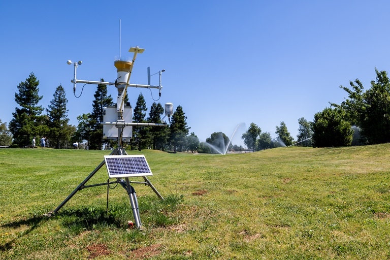
CIMIS operates a network of more than 145 automated weather stations throughout California.
These stations measure conditions that affect how quickly water evaporates from soil and moves through plants.
Measurements include air temperature, humidity, wind, and solar radiation.
The stations collect readings every minute, while the system retrieves information from the stations hourly.
The Department of Water Resources checks the data for accuracy before calculating water loss estimates and storing the information.
Users can select weather stations that represent conditions similar to those in their own areas.
The system also provides historical information that can be used to examine weather patterns and irrigation needs over time.
New Mobile App Makes Information Easier to Access.
The November 16 upgrade also introduced the Department of Water Resources’ first mobile application for CIMIS.
The free app allows users to access weather station information and statewide estimates directly from their phones.
Users can examine trends, explore data, and save frequently used locations.
The app is available for Apple and Android devices.
Other improvements include faster data delivery for software applications, secure file transfers, and access to information through ArcGIS Online, a mapping and geographic analysis platform.
According to the Department of Water Resources, the upgraded data service can deliver information up to 10 times faster than the previous version.
The system also uses updated national engineering standards to calculate water loss estimates.
A Long-Running Tool for Water Management.
For more than 40 years, CIMIS has provided information intended to help California irrigation users manage water more efficiently.
The Department of Water Resources identifies water, energy, and cost savings as benefits of using accurate irrigation information.
With CIMIS 3.0, that information is now available through more detailed maps, updated reporting tools, and mobile devices.
The upgraded system continues to serve farmers, landscape managers, irrigation districts, and water professionals who rely on weather information to make watering decisions.
Image via the California Department of Water Resources: “California Department of Water Resources’ California Irrigation Management Information System (CIMIS) Program celebrates a new station with WildHawk Golf Course and Regional Water Authority in Sacramento County.”