
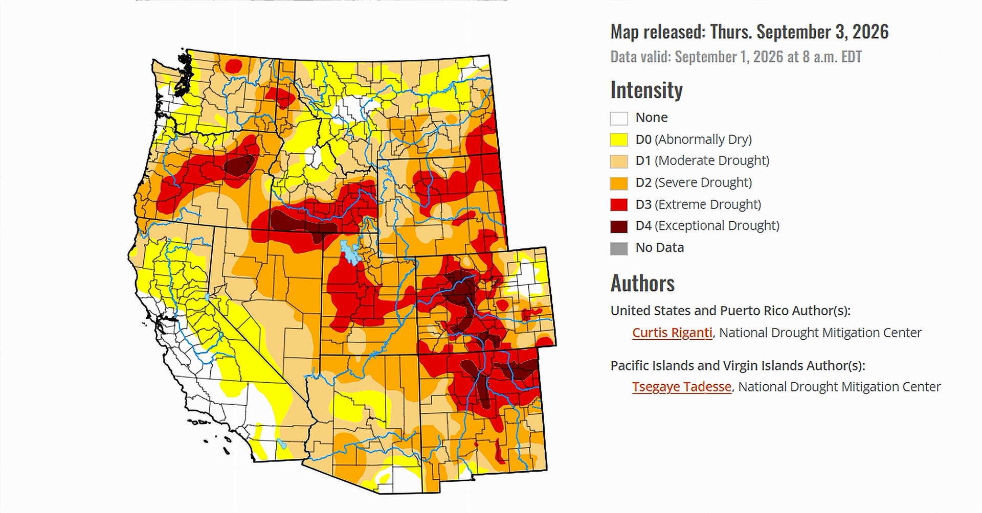
- Drought worsened across large parts of the central United States as hot, dry weather continued.
- Rain brought some improvement to Colorado, Wyoming and Utah, but widespread drought remained.
- Extreme and exceptional drought expanded in parts of Colorado that missed heavier monsoon rainfall.
- Moderate drought expanded in northern California after a lack of winter snow and recent hot, dry weather.
Saturday, September 5, 2026 — Across the United States, drought conditions moved in different directions during the week ending September 1. Rain brought relief to some areas, while persistent heat and dry weather caused drought to spread or intensify elsewhere.
The sharpest deterioration occurred across parts of the central United States. A rapidly developing “flash drought” stretched from Texas northeast through Oklahoma and southern Kansas into Missouri, Arkansas, northern Mississippi and portions of western Tennessee.
Agricultural impacts continued in many of those areas, while fire danger increased in some locations.
Conditions were more mixed across the West, including the seven Colorado River Basin states. Monsoon rainfall helped some areas, but it was not enough to erase widespread short- and long-term drought.
Monsoon Rain Brings Some Western Relief.
Locally heavy North American Monsoon rainfall reached parts of Arizona, Utah and the Rocky Mountains in Colorado during the week.
Colorado saw some of the most noticeable improvement.
Areas west of the Front Range improved following recent rainfall. Eastern Colorado also saw improvement after rainfall reduced short-term precipitation deficits and helped soil moisture and streamflow.
Wyoming benefited as well. Rainfall ranging from about one-half inch to 2 inches fell across portions of Colorado and Wyoming, and drought conditions improved in parts of southern and eastern Wyoming.
The improvements, however, came against a backdrop of continuing water shortages. The Drought Monitor reported that streamflow remained low in portions of the western High Plains because of poor high-elevation snow and warm temperatures during the water year.
Colorado Remains a Drought Trouble Spot.
The picture was especially complicated in Colorado.
While rainfall improved conditions in some locations west of the Front Range, widespread short- and long-term drought remained across central and western Colorado.
Some areas of south-central and southwest Colorado missed the heavier rainfall. There, long-term precipitation deficits became worse.
Heat added another problem. Temperatures were 4 to 6 degrees above normal in affected areas, increasing the atmosphere’s demand for moisture. Extreme drought (D3) and exceptional drought (D4), the two most serious categories used by the U.S. Drought Monitor, expanded locally.
That meant Colorado experienced both improvement and deterioration during the same reporting period, depending largely on where the rain fell.
Utah Sees a Small Improvement.
Utah also received some relief.
Recent precipitation in western Utah reduced long-term precipitation deficits enough for the area classified in extreme drought (D3) to shrink slightly.
The improvement did not mean drought had ended. The Drought Monitor continued to describe widespread drought across the West, with temperatures warmer than normal through much of the region.
Most areas outside western Nevada, far northern California, Oregon and Washington were at least 2 to 4 degrees warmer than normal. Many locations were 4 to 10 degrees above normal.
Northern California Drought Expands.
California moved in the opposite direction.
Recent hot and dry weather, combined with a lack of winter snowpack, caused moderate drought (D1) to expand in northern California.
The Drought Monitor also cited short-term dryness and warmth in northern California as reasons for the deterioration.
More Rain Could Reach the West.
The outlook offered the possibility of additional precipitation in parts of the West.
Through the evening of September 7, however, dry weather was forecast to continue across much of the central and south-central United States, including eastern New Mexico and Colorado.
For September 8 through September 12, the Climate Prediction Center favored above-normal precipitation across much of the western United States. The strongest chances extended from the Continental Divide into the Great Basin.
Temperatures during that period were expected to be closer to normal across the western half of the West, with slightly increased chances for below-normal temperatures in western Nevada and nearby portions of California and Oregon.
For the Colorado River Basin, the week’s report showed a familiar patchwork: rain improved drought in portions of Colorado, Wyoming and Utah, while other areas remained dry or deteriorated. Across central and western Colorado in particular, widespread short- and long-term drought remained despite the arrival of monsoon moisture.


I haven’t read that, but it sounds interesting. I hope we’re not headed to something worse than the Dust Bowl.
Thank you for sharing the information. There have been a number of proposals over the years to move water from wetter regions of the United States to the arid West, including occasional discussion of moving Great Lakes water westward. These ideas are certainly interesting, but they also raise significant legal, political, environmental, engineering and economic questions. Large-scale interstate water transfers are something we may explore in a future Western Water Highlights program. Thanks for joining the conversation.