- About 4.2 million gallons of untreated sewage entered the Arkansas River in late August.
- John Martin Reservoir reopened after testing showed bacteria had fallen to acceptable recreational levels.
- A water-contact advisory remained in effect for part of the Arkansas River as of September 4.
- Most fresh produce downstream was irrigated with groundwater this year because of drought.
- State officials and scientists are continuing to study possible effects on agriculture.
Wednesday, September 16, 2026 — A massive sewage spill into Colorado’s Arkansas River is raising new questions for farmers in the Lower Arkansas Valley, even as water quality has improved in some areas affected by the contamination.
About 4.2 million gallons of untreated wastewater escaped from the City of Pueblo’s wastewater treatment system between August 26 and 27, 2026. The sewage entered the Arkansas River and traveled downstream through southeastern Colorado.
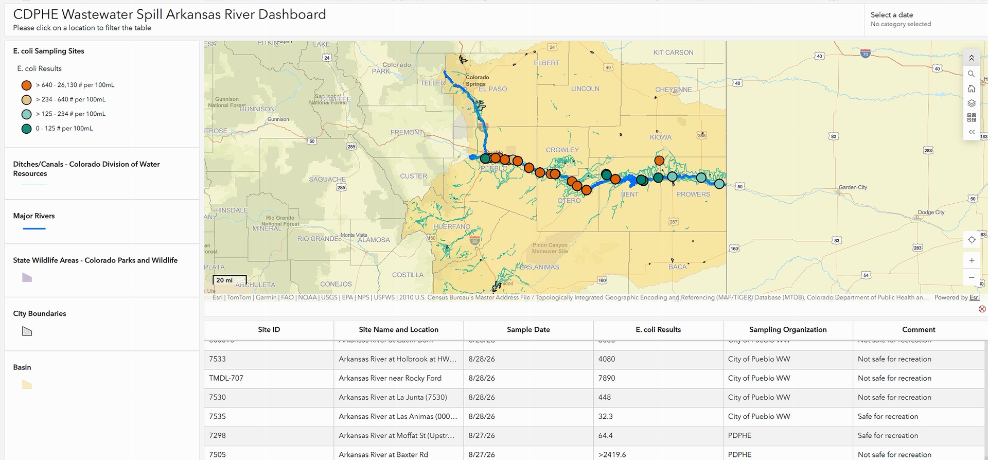
Initial testing found extremely high levels of E. coli bacteria downstream from the spill. Health officials warned people to stay out of affected portions of the river while agencies continued testing the water.
Nearly three weeks later, attention is also turning to another concern: agriculture.
Most Fresh Produce Used Groundwater.
The Lower Arkansas Valley is an important farming area, and the spill occurred near the end of the summer growing season.
The Lower Arkansas Valley Water Conservancy District said September 13 that most fresh produce grown downstream of the spill had been irrigated with groundwater this year rather than Arkansas River water.
Drought was the reason.
“Fortunately, this year, the vast majority of fresh produce grown downstream of the spill has relied on groundwater, rather than surface water from the Arkansas River, to irrigate their crops because of drought conditions,” the district said.
The district also said farms served by the Bessemer Ditch were not affected by the spill. The ditch diverts water directly from Pueblo Reservoir, which is upstream from where the sewage entered the river.
That does not mean all agricultural questions have been resolved.
Some farmers rely on surface water taken directly from the Arkansas River. The Lower Arkansas Valley Water Conservancy District described the spill as a challenge for those producers.
The district said it is meeting regularly with the Colorado Department of Public Health and Environment and Colorado Department of Agriculture to exchange information and understand possible agricultural effects.
The Colorado Department of Agriculture is also working with Colorado State University to assemble a team of water-quality and crop scientists to provide guidance to Lower Arkansas Valley producers.
Reservoir Advisory Lifted.
Encouraging news has come from farther downstream.
Colorado health officials lifted the water-contact advisory for John Martin Reservoir on September 4 after repeated testing showed E. coli concentrations had returned to levels consistent with state recreational standards.
“Our priority throughout this event has been to protect public health through rigorous science and rapid, transparent communication,” said Nicole Rowan, director of the state’s Water Quality Control Division.
Rowan said coordinated sampling had verified that E. coli levels at the reservoir were back within acceptable thresholds, allowing recreational access to resume.
Testing was scheduled to continue after the advisory was lifted.
Part of the River Remained Under Advisory.
The September 4 announcement did not clear the entire Arkansas River.
At that time, a water-contact advisory remained in effect from the confluence of Fountain Creek and the Arkansas River downstream through La Junta because E. coli results remained elevated.
State water-quality and wildlife officials said monitoring would continue along the Arkansas River.
The original advisory had covered a much larger area, extending downstream through John Martin Reservoir and affecting communities including Blende, Avondale, Fowler, Manzanola, Rocky Ford, La Junta and Las Animas.
How the Sewage Reached the River.
The spill was traced to an unusual failure inside Pueblo’s wastewater system.
According to the City of Pueblo, a wastewater pipe ran inside a stormwater pipe. A hole had been cut into the wastewater pipe many years earlier and later patched with concrete.
Over time, the concrete patch slipped out of place.
While bypass pumps were operating, pressure forced untreated wastewater through the opening and into the stormwater system. That system drains into the Arkansas River.
The discharge was stopped at approximately 11:45 a.m. on August 27. Officials later estimated that about 4.25 million gallons of untreated sewage entered the river.
Drinking Water Systems Showed No Impacts.
Despite the size of the release, state officials reported August 28 that there was no evidence the spill had affected public drinking water systems.
Public water systems were notified about the spill and could shut down intakes or take other precautions.
People using private wells or other private water supplies who believed their water might have been affected were advised to contact the Colorado Water Quality Control Division.
Questions Remain for Some Farmers.
The immediate emergency has eased in some places, particularly at John Martin Reservoir. But agencies are still examining what the spill could mean for farmers who depend on Arkansas River surface water.
The Lower Arkansas Valley Water Conservancy District said it intends to continue working with state agencies as more information becomes available.
For the region’s produce growers, the timing is significant. September marks the final weeks of the farm-market season, and the Pueblo Chile & Frijoles Festival is scheduled for September 18 through 20.
The district is encouraging the public to continue supporting Lower Arkansas Valley farmers while scientists and state agencies work through the remaining questions surrounding the spill.
Pictured: Screenshot of the CDPHE Wastewater Spill Arkansas River Dashboard. Access data at the CDPHE site at https://cdphe.maps.arcgis.com/apps/dashboards/07b4a30fab8f422f9ae5051d531d5cc0#