- El Niño is underway in the tropical Pacific, and forecasters expect it to reach very strong intensity during fall and winter 2026-27.
- Federal outlooks favor a wetter-than-normal winter across much of the Southwest, but the effect on the Colorado River depends on where mountain snow falls.
- One strong winter could raise reservoir levels, but it cannot correct the long-term gap between the river’s supply and demand.
Thursday, August 20, 2026 — The phrase “Super El Niño” is circulating again, and this time there is a scientific reason behind it.
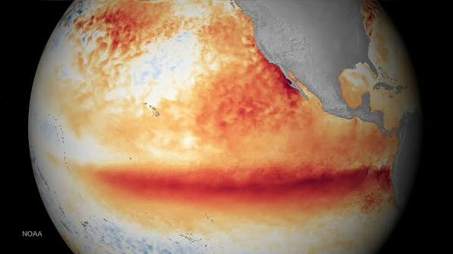
El Niño is already present in the tropical Pacific Ocean, and forecasts point to an exceptionally strong event during the fall and winter of 2026-27.
The National Oceanic and Atmospheric Administration, known as NOAA, reported in August 2026 that the chance of a very strong El Niño during October through December had risen to about 95 percent, up from 81 percent in its July assessment. NOAA measures that category using the Relative Oceanic Niño Index, or RONI, which tracks unusual warming in the tropical Pacific relative to the wider tropics. A very strong event would rank among the largest El Niños in records dating to 1950.
NOAA’s Climate Prediction Center, or CPC, describes the August odds as greater than 90 percent for a very strong event during the Northern Hemisphere fall and winter. Its August outlook also placed a 69 percent chance that the index would reach at least positive 2.5 degrees Celsius, a level that would exceed previous El Niño events in the modern record.
Experimental modeling from NOAA’s Geophysical Fluid Dynamics Laboratory, or GFDL, points in the same direction. Its August forecast found that all 30 model simulations produced an El Niño capable of competing with the strongest events in the historical record. The models expect the event to peak between October 2026 and January 2027.
That raises a direct question for the West.
Could a Super El Niño finally deliver a large water year to the Colorado River Basin?
Possibly. But the answer is more complicated than the idea that El Niño simply means rain.
What a “Super El Niño” Means.
El Niño begins thousands of miles from the Colorado River. Under normal conditions, trade winds push warm surface water westward across the tropical Pacific toward Asia. During El Niño, those winds weaken, and unusually warm water spreads eastward across the central and eastern equatorial Pacific.
That large area of warm ocean shifts where thunderstorms form in the tropics. Those shifts can change atmospheric circulation and jet streams around the world. That is how a change in the Pacific near the equator can influence winter storms in California, Arizona, Colorado and other western states.
“Super El Niño” is not an official scientific classification. NOAA describes events as weak, moderate, strong or very strong based on temperature measurements and other indicators. The term is commonly applied to the most powerful events, such as those of 1982-83, 1997-98 and 2015-16. NOAA’s records place 1982-83 and 1997-98 among the largest events measured, and 2015-16 also reached extraordinary strength. The developing 2026 event may join that group.
One caution applies. The strength of El Niño does not determine exactly what weather will occur in any single location. NOAA states that even the strongest El Niño events do not produce the expected effects everywhere. El Niño changes the odds. It does not dictate the weather.
A Global Weather Disruptor.
El Niño’s effects reach far beyond the American Southwest. The World Meteorological Organization, or WMO, reported that El Niño was intensifying steadily and was expected to become a strong event during the August through October 2026 season. The organization expects the event to push temperatures above normal across large parts of the world while shifting rainfall patterns.
Historically, El Niño tends to bring wetter conditions to parts of eastern Africa, southern South America and the eastern tropical Pacific. At the same time, drought risk can rise in places such as Indonesia, Australia and parts of southern Africa. Those patterns are not identical during every event. Other forces, including ocean temperatures outside the tropical Pacific, the Indian Ocean Dipole, atmospheric circulation and ordinary weather variability, can strengthen, weaken or move El Niño’s effects. That factor carries added weight in 2026 because global ocean temperatures remain unusually warm.
What Usually Happens in the United States.
El Niño’s clearest effects on the United States generally occur during winter. A stronger-than-normal jet stream tends to stretch eastward across the Pacific and shift south. That favors a more active southern storm track.
As a result, El Niño winters have historically been wetter across parts of California, the Southwest, and the southern United States, and warmer and often drier across parts of the northern United States.
NOAA’s August seasonal outlook is broadly consistent with that pattern. It favors above-normal precipitation across much of the West, beginning in Southern California and the Desert Southwest and extending into the Great Basin and the central Rocky Mountains. The wetter signal then expands across much of the southern United States as winter develops.
That sounds promising for the Colorado River. This is where geography becomes important.
The Colorado River Basin Does Not Respond as One Place.
The Colorado River Basin covers parts of seven states: Arizona, California, Colorado, Nevada, New Mexico, Utah, and Wyoming. Weather across that large region can differ sharply during the same winter.
The places that receive the most El Niño precipitation are not always the places that produce the most Colorado River water. Most Colorado River runoff begins as mountain snow, particularly in the Upper Basin. A wet winter in Southern California or central Arizona can be good news locally without producing a comparable rise in water flowing into Lake Powell. For the river system, where the precipitation falls matters nearly as much as how much falls.
California: One of the Strongest El Niño Signals.
California is among the states most strongly linked to powerful El Niño winters. During major events, the Pacific storm track can shift south and send repeated storms into the state. The winter of 1997-98 became a well-known example, with heavy precipitation, flooding, landslides and coastal damage across parts of California.
California can gain large water benefits from El Niño, along with large hazards. Heavy rain can refill reservoirs and improve soil moisture, and mountain storms can build Sierra Nevada snowpack. Intense atmospheric rivers falling on saturated ground can also cause flooding and landslides.
California’s Colorado River supplies add another factor. A wet Sierra Nevada winter can greatly improve California’s overall water picture, but Sierra runoff does not flow into the Colorado River. The benefit to the Colorado system depends on what happens farther east.
Arizona: Better Odds for a Wet Winter.
Arizona has one of the clearer El Niño relationships in the Colorado River Basin. NOAA’s analysis of past strong events shows a consistent tendency toward wetter fall and winter conditions across the state. A very strong El Niño improves those odds, though it does not guarantee a wet winter in 2026-27.
Wetter conditions could benefit central and southern Arizona watersheds, groundwater recharge, soil moisture, and reservoirs on systems such as the Salt and Verde rivers. Much of that water does not reach the Colorado River. A wet winter in Phoenix or Tucson is not the same as a wet winter in the Colorado River headwaters.
New Mexico: Potentially Significant Benefits.
New Mexico also falls within the southern region where El Niño can increase cool season precipitation. Winter and spring storms could improve mountain snowpack and water supplies in parts of the state. That matters most in the San Juan River Basin. Snowfall in the San Juan Mountains of southwestern Colorado and northern New Mexico can directly contribute to flows in the Colorado River system. This is one area where a favorable El Niño storm track could reach Lake Powell.
Colorado: The Complicated Middle Ground.
Colorado is where the simple El Niño story begins to break down. Research summarized by the Western Water Assessment and the National Integrated Drought Information System shows that strong El Niño conditions have historically increased the likelihood of wetter-than-normal conditions across much of Colorado, particularly during fall and spring.
There is an important exception. North-central Colorado mountains can turn dry during the middle of strong El Niño winters. That matters because northern and central mountain watersheds produce a large share of Colorado River runoff. Colorado can therefore have an El Niño winter that looks wet statewide, even as some key headwater areas receive less snow. Southern Colorado often carries a stronger El Niño signal, which could favor the San Juan Mountains and other southern watersheds. The location of that snow will be critical for water managers.
Utah: Potential Benefits, but No Guarantee.
Utah sits between the stronger southern El Niño signal and the weaker or sometimes opposite signal to the north. Southern Utah may benefit more reliably from an active southern storm track. Northern Utah is less predictable. An El Niño winter could improve snowpack in parts of the state without producing extraordinary runoff throughout the Green and Colorado River systems. This is another reason basin-wide snow measurements will matter more than the El Niño label.
Nevada: Wet Weather Does Not Always Mean Colorado River Water.
Southern Nevada can receive increased winter precipitation during some El Niño events, which can improve local soil moisture and mountain snow. Las Vegas receives nearly all of its municipal water from Lake Mead. Rain falling over Las Vegas adds very little to the reservoir compared with runoff that begins hundreds of miles upstream. Lake Mead depends heavily on water passing through Lake Powell from the Upper Colorado River Basin. A rainy Nevada winter can occur without a large Lake Mead recovery.
Wyoming: Perhaps the Biggest Question Mark.
Wyoming sits near the northern edge of the Colorado River Basin, which places it farther from El Niño’s strongest traditional wet signal. The Green River begins in Wyoming and is one of the Colorado River’s major tributaries. If El Niño shifts the winter storm track southward, parts of Wyoming could receive average or below average precipitation while Arizona and Southern California turn unusually wet. That would be an important warning sign. A very wet Southwest winter does not necessarily equal a strong Colorado River runoff year.
History Shows Why Caution Is Necessary.
The giant El Niños offer useful comparisons and show the danger of assuming that every powerful event produces the same outcome. The 1982-83 El Niño was one of the strongest measured and contributed to an exceptionally wet period across much of the West. The 1997-98 El Niño produced extraordinary precipitation and destructive flooding in California and the Southwest.
Then came 2015-16. That event became one of the strongest ever observed. California entered the winter hoping for major drought relief. Parts of the state received substantial precipitation, but Southern California did not receive the extraordinary rainfall many expected, because the storm track ran farther north. The distribution of precipitation across the West did not simply repeat 1982-83 or 1997-98.
Colorado offers another lesson. During strong El Niño events, southern parts of the state can do well while north-central mountain areas stay relatively dry.
There is no single Super El Niño winter. Every event interacts with a different atmosphere and ocean.
The Biggest Question Is Snow, Not Rain.
For the Colorado River, the most important measure will move away from tropical Pacific temperatures and into the mountains. Beginning in fall 2026, water managers will watch snow water equivalent measurements across Colorado, Wyoming, Utah and New Mexico. Those measurements show how much water the mountain snowpack actually holds.
Even that will not settle the question. Temperature matters. A warmer winter can cause more precipitation to fall as rain instead of snow at lower elevations. Warm spring conditions can melt snow early. Dry soils can absorb snowmelt before it reaches streams. Those processes can reduce the amount of water that finally reaches Lake Powell. That is one reason modern Colorado River hydrology cannot be predicted from winter precipitation totals alone.
Could El Niño Raise Lake Powell and Lake Mead?
Yes. If the developing El Niño produces a very snowy winter across the Upper Colorado River Basin, spring runoff could increase substantially. That would raise inflows into Lake Powell. Water released from Powell flows downstream toward Lake Mead, so a large runoff year could improve conditions in both reservoirs.
There is a difference between improvement and recovery. The Colorado River has experienced more than two decades of drought, unusually high temperatures, and declining reservoir storage. One wet year can make a major difference. It cannot resolve the river’s larger structural problems. The basin still faces a basic imbalance between available water and the demands placed on the system.
The Best-Case Scenario.
For the Colorado River, the ideal El Niño would not simply produce heavy rain in California and Arizona. It would push repeated cool Pacific storms into the Rocky Mountains. Those storms would build deep snowpack across the Colorado, Green, Gunnison and San Juan river headwaters. Temperatures would stay cool enough to preserve that snow through winter. Spring would arrive gradually rather than suddenly. Soils would be wet enough that a large share of the melting snow would reach streams. That combination could produce a strong runoff year.
The Other Possibility.
There is another scenario. California could see major storms. Arizona and New Mexico could receive above-normal winter precipitation. Southern Colorado could record excellent snow. Headwater areas farther north could stay near normal, or even below normal. Under that outcome, headlines might describe an extraordinary El Niño winter while Lake Powell receives a far less extraordinary runoff. Both outcomes are scientifically plausible.
Can a Super El Niño “Save” the Colorado River?
No single winter can save the Colorado River. The developing El Niño may give the basin better odds. A strong or very strong El Niño increases the chances of wet weather across much of the Southwest. NOAA’s August seasonal outlook already favors above-normal precipitation extending from Southern California and the Desert Southwest into parts of the Great Basin and central Rockies.
The most important measurements have not yet been taken. Between roughly December 2026 and April 2027, the real story will appear in mountain snow gauges across Colorado, Utah, Wyoming and New Mexico. If those gauges climb well above normal, the developing Super El Niño could become very important to the Colorado River. If most of the precipitation falls farther south and west, it could still produce a memorable, possibly damaging wet winter without fundamentally changing Colorado River hydrology.
The Pacific Ocean is setting the stage. The Rocky Mountains will determine how much water the Colorado River receives.
Scientific Sources and Further Reading.
- NOAA Climate Prediction Center — ENSO Diagnostic Discussion, https://www.cpc.ncep.noaa.gov/products/analysis_monitoring/enso_advisory/ensodisc.shtml

- NOAA Climate Prediction Center — ENSO Strength Probabilities, https://www.cpc.ncep.noaa.gov/products/analysis_monitoring/enso/roni/strengths/
- NOAA Geophysical Fluid Dynamics Laboratory — August 2026 El Niño Predictions, https://www.gfdl.noaa.gov/prediction/august-2026-el-nino-predictions/
- NOAA Climate Prediction Center — Seasonal Outlooks, https://www.cpc.ncep.noaa.gov/products/predictions/long_range/
- NOAA Climate Prediction Center — North American Winter ENSO Patterns, https://www.cpc.ncep.noaa.gov/products/analysis_monitoring/ensocycle/nawinter.shtml
- NOAA Climate Prediction Center — El Niño Temperature and Precipitation Patterns, https://www.cpc.ncep.noaa.gov/products/analysis_monitoring/ensocycle/elninosfc.shtml
- NOAA Pacific Marine Environmental Laboratory — What Is El Niño? https://www.pmel.noaa.gov/elnino/what-is-el-nino
- World Meteorological Organization — Strong El Niño Expected to Intensify, https://wmo.int/news/media-centre/strong-el-nino-expected-intensify
- International Research Institute for Climate and Society — ENSO Forecast, https://iri.columbia.edu/our-expertise/climate/forecasts/enso/current/
- Western Water Assessment — Colorado River Basin Climate and Hydrology: State of the Science, https://wwa.colorado.edu/resources/colorado-river-resources/CRBreport
- National Integrated Drought Information System — El Niño Impacts for Colorado, https://www.drought.gov/documents/el-nino-impacts-colorado-fall-winter-spring-2015-16
- NOAA Climate Prediction Center — 1997 Southwest El Niño Analysis, https://www.cpc.ncep.noaa.gov/products/special_summaries/97_2/
- NOAA Climate Prediction Center — 1997–98 El Niño Climate Summary, https://www.cpc.ncep.noaa.gov/products/special_summaries/97_3/